Preparation:
All equipment was prepared and loaded in the car the previous day following the activation of Buchberg. This activation was initially planned for a leisurely start but brought forward as it looks like there “might” be some 7MHz long path possibilities into VK/ZL. So a pre-7am start was planned for.
I actually woke earlier as the dog woke me up barking at 4 am when the neighbours cat came past the back door! after dealing with that I tried to get a little more sleep before the alarm went off. I was on the road by 6:50am (0550 UTC) and all went to plan heading for my first summit “Zwieselberg” that I had activated a couple of years ago, so I knew the route but despite that I put the Navi (GPS) on in the car to avoid any problems. One SOTA operator had told me the week prior that there were trees blocking the road and hence a longer walk is needed. As this was a day after some very heavy winds, i thought he meant that the trees had been blown down. in that case they will have been cleared by now right? well that wasn’t what he meant – see later. First of all we need to get to the summit …
The main road closed on my route someway away from Zwieselberg – at first I thought it was just in the village where I saw the first signs so I diverted around the outside of that village (Bruggen) and that was the problem solved. That was not to be the case, as I approached the small town of Bernbeuren (under the SOTA summit Auerberg) I could see the main road into the town was dug up! The diversion was NOT well sign-posted. In fact at one point it had you going down a “restricted for motor vehicles” road – but everyone else went down there, so I followed them. The Navi (GPS) doesn’t help when a road is closed, it keeps trying to route you back to the same point and indeed the restricted road it didn’t even have in its maps!
The Activation (Zwieselberg):
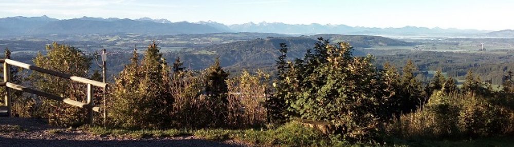
So after arriving at Vorderzwieselberg and driving up the private road (there’s a sign: public access but at your own risk), I find what the previous activator meant! it wasn’t that one or two trees had been blown over rather that tens of trees had been cut down and stacked not only along the side of the road but also IN the road in the area where I have parked previously (see photos below). with a bit of trepidation, I decide to drive up and park on the grass bank behind some of the logs. the picture doesn’t show the angle very well, but I can say it took all my strength to open the driver’s door wide enough, to be able to get out. Going to the rear of the car, even with it in gear and the hand brake on, I decided to lodge my large sun umbrella base under the back wheel to act as a check. It was not an ideal situation but it looked solid enough. So I now unpacked the car, loaded myself up with my normal two bags, the 10 metre mast and the Surveyors tripod and set off up the steep track (about 85 metre rise in less than a kilometre would be my estimate, to the summit and summit cross. part of the way up, the ground was still muddy and even with my good hiking boots on, I felt myself sliding, some sideways walking solved that problem and indeed I made it up to the top of the summit as the sun was rising into the sky. This summit has lots of space so I decided to put up the linked VP2E that I had used the previous day on Buchberg. Although there is lots of space, the ground does curve down quite a lot, meaning the ends of the antenna were closer to the ground than I would have liked. But “it is what it is”. The views from this summit are stunning and although it was quite cold, the fact that the sun was shining helped me to start to forget the “aggro” from the closed road and the difficult parking situation both of which had cost me valuable time.
The log shows that despite the expectations and my timing being “OK” despite the delays, no VK contacts were achieved. I had scheds with Ernie VK3DET in Victoria, Australia on both 40m & 20m but to no avail. The conditions were simply not good enough. Added to that there was a “clicking” type of QRM on 40m and something that soundeD like OTHR from 14.140 to 14.350 on 20m. I thought the “clicking” QRM may have been a faulty electrical farmers fence but the noise was still there on the next summit, so it seems it was atmospheric. The 20m QRM was however definitely man-made.
Despite the noise I managed 5 contacts on 40m and in fact it was almost 6 contacts but one I had to mark as a “no contact” as I could not copy my report. I did stay longer, calling and hoping that the bands would improve to let me get through to Ernie in Australia but to no avail. As I had lost time already and I knew that the trip to the next summit (which I hadn’t activated before) would take sometime as the 7-8 km away Senkelekopf needed an over 30 minute drive to get there as there are no direct roads, I decided at 0810 UTC to pack up and head back to the car.
Little did I know that I was about to get my next challenge. The car was still where I had parked it and I could load all the equipment into the back of the car but the placement of the large trees would make it difficult to turn around (in hindsight, I should have reversed back down off the bank onto the road at the same angle that I came up and reversed back down the whole of the private road). The problem as well as the large logs was that the ground under the car was waterlogged and hence grip was limited. Unfortunately my car, like the majority these days is front wheel drive, so as I backed down the slop trying to turn the rear of the car, the driving wheels were still on the slippery surface. I was very aware of the line of logs directly behind my car and so I would stop and check and stop and check inch by inch until I got almost onto the road BUT the problem was the steering doesn’t work on such surfaces so I wasn’t able to turn the front of the car and trying to drive back up the bank to have another go simply spun the wheels. I did not want to have to walk down to the farm to see if they could help, so I looked around in the car to see what I might put under the front wheels to get some traction and decided on the canvas covers from two folding seats. These I jammed under the front wheels. They made a little difference but I was edging closer and closer to those logs behind me. I was at this point that I realised that when the wheels were spinning, the car was slowly sliding sideways on the muddy bank, so with some brake, clutch and accelerator “trickery” I manager to get the front of the car to slide sideways onto the road BEFORE the back of the car met the stacked logs. PHEW! That was close but after finding the canvas covers (which after a run through the washing machine are as good as new) and putting them in the back of the car, I was, at last, able to drive off in the right direction and on to Senkelekopf with the help of the Navi (GPS).
I’m sure the farmer will wonder what has happened to the grass bank, but if he hadn’t stacked the logs on the road rather than at the side of the road (where there was space) I would never have had this problem!
The Activation (Senkelekopf):
The drive to Senkelekopf from Zwieselberg was along single track farm roads for most of the way and when I arrived at the suggested starting point for the climb, by a country guest house, I wondered if someone would complain about me parking there. There was a gravelled spot for parking two cars which didn’t appear to be on anyones actual property (I expect it was the parking for the chapel, for when they have services). So I parked there and decided what to take with me for this summit I actually took the same set-up as I had for Zwieselberg, except I was expecting to have to use the SOTABeams linked dipole antenna rather than the VP2E, but in case I could get that out, I took the 10 metre mast again not the lighter 6 metre one. In my small rucksack I had 2 VP2E antennas, The SOTABeams linked dipole and the Aerial-51 40m OCF antenna.
This is also a steep climb. There are other not so steep routes but they are a lot longer – nice if you have the time. I took my time climbing up the track, stopping to get my breath and take some photos as I climbed. Eventually I saw the summit. There is some large building near to it, which is obviously accessible via one of the other routes with a tractor or similar – it seems to be some kind of farm building. While approaching it a squirrel ran across about 10 metres in front of me and went up a tree. To the left of the building the ground rises up to the actual summit and on top of that is the Holy Cross – this appears to be totalled fenced in and surrounded within the fencing with bushes and small trees. It’s obvious public access to it is not invited. In any case at a similar height behind the cross there was some fairly flat land where I could easily set-up. There was not enough space for the 40m VP2E so I decided to put up my “old faithful” the SOTABeams Bandhopper linked dipole.
Once the surveyors tripod was set up and the 10m mast within it, it took no time to get the rest of the station deployed on my painters sheet on the ground next to the tripod. I was on the air just after 1000 UTC and there were some other summits being activated, so I tuned around and I could hear a couple of the activators and despite my determined calling, neither of them came back to me. So I picked a free frequency, spotted myself and started calling CQ – nothing. Perhaps there was someone on the same frequency that I can’t hear because they are within my skip zone? tried another frequency, still no calls. Then there was QRM on the frequency, tried another frequency. This is all very strange! I check the rig, all appeared OK. So I dropped the antenna, switched to 20m and got my first calls after being on the summit nearly an hour. 20m wasn’t that good though, so I went back to 40m. Again I could hear plenty of stations but none of them wanted to work me. What could be wrong? split frequency? no. Wrong sideband? no. OK, it had to be the antenna! I lowered the mast took off the linked dipole and put up the Aerial-51 OCF. As soon as I spotted myself and called, I had a pile-up – everything was now working – so what was wrong with the other antenna?
Then the battery box failed – what now? I opened the box and found that one of the diodes that I use to drop the voltage down to an acceptable level from my 4S LIPOs had come loose – I pushed it back in place and all worked again. By this point I had 13 calls in the log and was again running late to my schedule, so it was time at 1130 UTC to pack up and head off.
As I was rolling up the SOTABeams linked dipole the wire from the 20m link came away in my hand – THAT had been the problem! that was the reason why it was OK on 20m but not on 40m. when on 40m, one half of the dipole would have been the correct length while the other side would have been too short. I wonder if this caused the rig to draw more power with the bad VSWR and that was the reason, combined with the extended length of time I was using the rig, that one end of one of the diodes de-soldered itself?
At this point with the series of problems I had had, I wondered whether to cancel my third activation and head home? I decided to make the call once I was back at the car and could see how long it would take to get to Eisenberg – a summit that I have activated several times so I knew what was possible and what not.
After getting to the car and packing the gear in, the Navi told me I’m only about a 1/4 hours drive to the next summit and I still had time to do it, so I decided to include it in the day’s activations as planned. So off to Castle Eisenburg!
The Activation (Eisenberg):
On arriving at Eisenberg, I decided not to take the 10 metre mast, the tripod or the VP2E antennas and stick to the 6 metre mast and the Aerial-51 OCF dipole. I’d just get the minimum 4 contacts and then head back down to the car park and to the restaurant for a well-earned “Weissbier” (Wheat beer).
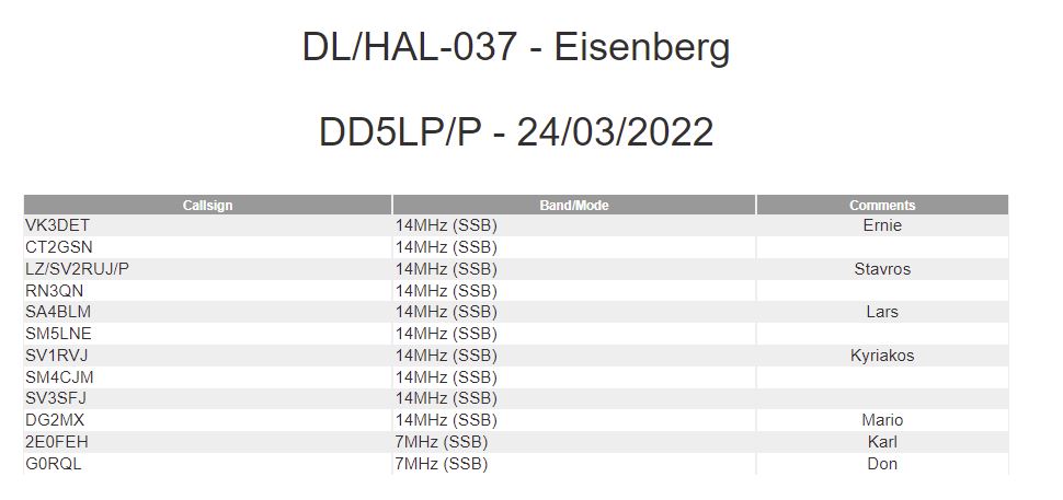
My favourite spot at this summit is out on the wooden platform that has been built onto the end of the ruins. It has convenient posts to support the mast and the ends of the antenna can be tied off to the wooden railings. I set myself up in a corner on my painters sheet quite quickly as there were no tourists there when I arrived. they came later but caused no issues or interruptions. Starting at 1300 UTC all went well with seven 40m contacts in seven minutes. Just as I finished the last QSO of the seven I lost power from the battery box again and looking at it this time, the diode that had disconnected itself at Senkelekopf has disconnected at both ends this time and so there was no “quick fix”. I no longer use the bump-up bump-down “buck” voltage converters as they create RFI, hence the reason that I switched to the “quiet” diodes but these do need to dissipate some power as heat. After getting home I re-soldered the diode back in place as this is the first time in 10 activations that this has happened. If the problem occurs again I’ll add a second run of terminal block so that the diodes are no longer soldered together.
I packed up at 1310 UTC following the loss of power and headed back to the car park, dropped in all the gear into the car and went across to sit outside the restaurant in the sun, gaze at the views and drink a nice cool, well-earned, Weissbier. A great end to a busy day.
The drive home was a route I knew without needing to use the Navi and went without any more incidents.
That’s 15 activating points today 3 x 2 point summits each with a 3 point winter bonus. There’s still three more summits, all with long walk-ins located a fair distance from the home QTH which, if the weather keeps fine I will try to fit in, in one day, before the winter bonus finishes.
Photos (Zwieselberg):
This slideshow requires JavaScript.
Photos (Senkelekopf):
This slideshow requires JavaScript.
Photos (Eisenberg):
This slideshow requires JavaScript.
Equipment used:
Zwieselberg:
- Xiegu X108G plus battery box (2 x 5000maH hardcase LIPOs)
- Linked (40m/20m) VP2E antenna
- 10 metre DX-Wire fibreglass portable mast.
- Surveyors tripod.
- Smartphone PocketRxTx App and USB cable.
Senkelekopf:
- Xiegu X108G plus battery box (2 x 5000maH hardcase LIPOs).
- SOTABeams linked dipole.
- Aerial-51 OCF dipole antenna
- 10 metre DX-Wire fibreglass portable mast.
- Surveyors tripod.
- Thick plastic painters sheet.
- Smartphone PocketRxTx App and USB cable.
Eisenberg:
- Xiegu X108G plus battery box (2 x 5000maH hardcase LIPOs)
- 6 metre lambdahalbe fibreglass portable mast.
- Thick plastic painters sheet
- Aerial-51 OCF dipole antenna
- Smartphone PocketRxTx App and USB cable
Log (Zwieselberg):
 Log (Senkelekopf):
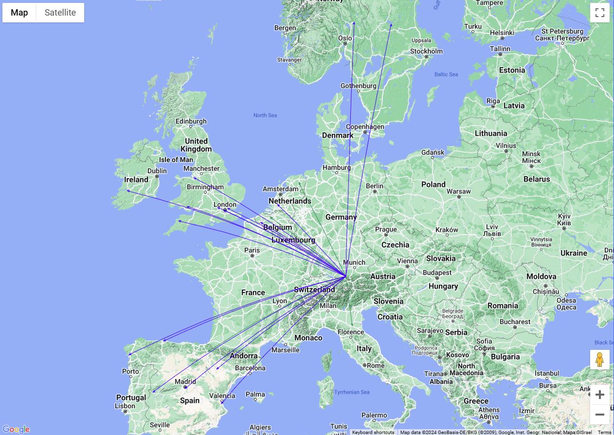
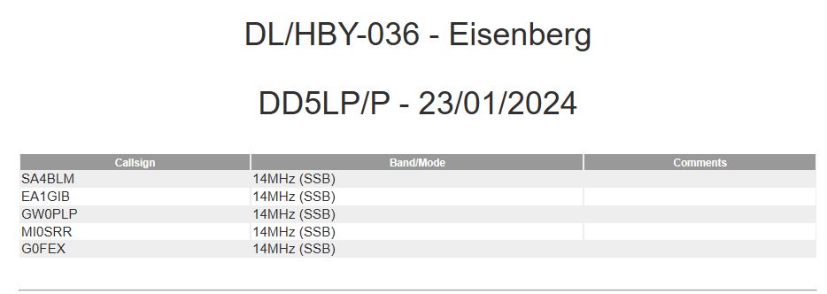
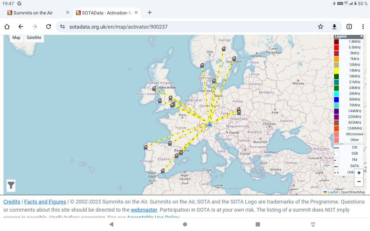
 Log (Eisenberg):
 Conclusions:
A really challenging day with a few problems to resolve but in the end, I managed the three summit activations almost on schedule and all were in sunshine, something that has been rare around here lately.
All three summits had long steep climbs of 80-100m. Despite the cumbersomeness and weight of the surveyors tripod it continues to be my favorite when going to a summit where I know mast supports are limited or to a new summit, where I don’t know whether there will be any supports at all (as was the case with Senkelekopf).
The propagation did not provide the expected improvements and no contacts into VK were possible although I was at the first summit at the right time for long path.
73 ’til the next Summit!


You must be logged in to post a comment.