Preparation:
A short 3-night break with the family to the Oberpfälz region (in English Upper Plantine) of Bavaria near the Czech/German border brought the chance of some portable radio activations. The problem of planning ahead with this trip was the uncertainty of the weather with high winds rain and even snow forecast as possibilities, this was going to have to be, grab the activation when you can. Our base for the short stay was the medieval town of Nabburg between Regensburg and Weiden. The Oberpfälzerwald nature park covers a large area of land around our base and hence the likelihood would be that POTA DE-0017 would be activated at the same time as a HEMA or SOTA summit. Very near to the town was an unactivated HEMA summit Darlesberg and this would most likely be the summit in the park, dual activation. The only reasonable summit to take the family to was Fahrenberg (DM/BM-321) and this 8-point, drive-up summit is in the next POTA park northwards, DE-0024 Nordlicheroberpfälzerwald NP so this could be a combined SOTA/POTA activation. On the way to our holiday flat, my wife wanted to see an art exhibition in Regensburg, so this was planned to coincide with me activating the Donaupark which is within Regensburg city.
The equipment would be the 6m telescopic fishing pole, umbrella base and the 404-UL OCF dipole from Aerial-59. The reason not to use the usual linked dipole was the probably need for band changing given the variable radio conditions present. This set-up would be used for the summit activations and the Komunica HF-Pro2-Plus-T on a mag mount on the car roof for the POTA activation from the Regensburg park (or any others that might be needed/possible).
The Activations
Tuesday 16th April – POTA DE-0376 DonauPark.
Apart from a delay finding my way to the parking area in this city park, the planned combination of dropping the wife off at the gallery, driving to the park, taking our dog for a walk, setting up the radio in the car, activating the park (10 contacts needed), closing down and packing away, taking the dog for her second walk and then going back to pick up my wife, went to plan and we were able to continue our journey on to our flat in Nabburg.
The activation itself brought in strong signals from around Europe on 20m but contacts number nine and ten took a little longer to get than the first eight which started me worrying a little that I would not manage the needed number of contacts in the time I had available. I tried 40 metres but with so many stations on that band, it was impossible to find a free frequency to call CQ on and when I did eventually find one, after calling CQ another station starting calling CQ without even asking if the frequency was free. It was a jungle of animals on 40 metres. Luckily I did manage to get the needed ten contacts on 20 metres. 10 metres was totally closed at the time.
Wednesday 17th April – POTA/SOTA DE-0024 NordlicherOberpfälzerWald NP / DM-BM-321 Fahrenberg.
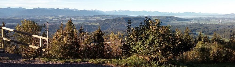
As the first day proper of our holiday we had planned to split this between radio and visiting the town of Weiden about 5 km north of Nabburg and that’s what we did, We spent the showery morning in Weiden (well worth a look, especially in the large church there) and by midday, we were heading up to the Fahrenberg. Unfortunately, the restaurant was not open on Wednesdays but again, it has a nice baroque-style church that is worth a visit. Behind the church, there is a perfect grassed area to put the mast and dipole up on and while it was sunny when we got there we did not know how long that would last, so I quickly set up and got calling. An impressive 25 callers got into the log in 16 minutes when the calls dried up on 20 metres I considered switching to 40 metres but as I could see black clouds approaching, I thought better of it and packed up the equipment. Just as I lifted my rucksack to my shoulder the first few flakes of snow started to fall, so timing could not have been better.
As we drove off the snow stopped but it was clear rain at least was on the way.
A good day’s radio operating and sightseeing.
Thursday 18th April – HEMA DL/HBY-226 Darlesberg
This should have been the easiest of the activations. The parking spot I had found on the map was less than 10 minutes drive away from our flat and then it was about a 1.25 km walk up a forest track to a picnic area followed by a smaller walking track of about one kilometre to the summit.
Admittedly with this activation, I carry my rucksack laden with gear for the longest distance but despite that, I did not expect any problems. I arrived at the parking spot around 9 am local time, loaded up and started up the forestry vehicles-only track, the start was a little steeper than I had expected but then it got better. I kept following the main track until after about 45 minutes, it started to go downhill, which made no sense. Rather than take my rucksack off to check my printed-out paper map, I decided to use my smartphone to check how much further it would be to the picnic area. What I saw was that I was on the wrong track. I used Google Maps to start with but then switched to the Mapy.cz app for confirmation which, unfortunately, it gave. about 10 minutes earlier I should have taken another much smaller muddy track (which on the maps is shown as being of the same type as the one I was on – it isn’t). In fact, I was now level with the summit but about 60 metres below it. There was a track to go up through the bush to the summit from this point, but it was a boggy mess and with the steep climb that would have been needed, I decided it was not a good option to try in the drizzle in a remote location. If I slipped there would be no one coming by to help.
I then had to face the decision, of whether to go back and go up the correct track and then join the official walking track to the summit, as originally planned or to abort the attempt. By the time I got back to the junction, I would have walked as far as I would have needed for the complete walk to the summit and then would have to face probably another 30-minute walk. I decided to cancel. Had I been carrying less weight or if the ground had not been so soaked I may have made a different decision. I know now not to rely on my memory of a paper map in my rucksack and either to have it out to check junction by junction or as I did on the return walk to the car, follow my position on an online map.
Friday 20th April – POTA DE-0017 OberpfälzerWald NP
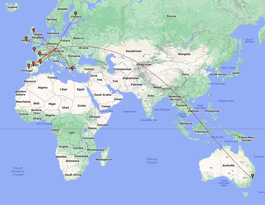
As the previous day’s activation (which would have been a HEMA/POTA one) had to be aborted, I was still left with the POTA activation available to coincide with a break to our return journey home to allow the dog to have a walk and so it was decided that another car based POTA activation would be made near Steinberger See about 30 minutes drive away from the flat, So after packing all our luggage into the car again (which of course got in the way later when I wanted to get to the radio gear) we set off but unfortunately in this area of Germany, the GPS (navi) doesn’t always see enough satellites to navigate accurately. There is also a US forces training base nearby, so what signals they may be putting out could also be part of the problem for car-based Euro-GPS systems. In any case, we ended up near Wackersdorf (famous for anti-nuclear-power rallies in the 70s) and found a parking spot near some woodland which would serve the purpose needed. So with my wife taking the dog for a walk, I set to, finding the radio equipment mounting the antenna and calling for POTA hunters. The contacts took longer than I am used to with SOTA and again there was time pressure to get the needed ten contacts but as this was around 0715 UTC, long-path on 20m was open into VK and I managed a Park-to-Park contact with VK2USH, which while difficult, especially as it suffered heavy QRM from another station was completed.
Photos:
POTA DE-0376 Donau Park
SOTA DM/BM-321 Fahrenberg / POTA DE-0024 NordlicherOberpfälzerWald NP
HEMA DL/HBY-226 Darlesberg (failed attempt)
POTA DE-0017 Oberpfälzerwald NP
Equipment taken:
- MountainTop 40-litre rucksack.
- Xiegu G90.
- Komunica Power HF-Pro2-PLUS-T loaded vertical antenna. (used with magnetic mount for the first and last activations).
- Three-magnet car roof antenna mount.
- Lamdahalbe 6m mini-mast (used on 2nd activation).
- Aerial-59 404-UL OCF dipole (used on 2nd activation).
- 4 Ah LifePO4 Eremit battery.
- 4.5 Ah LiHV battery (not used).
- Painter’s thick plastic sheet and gardener’s kneeling pad.
- Lightweight headphones.
- Smartphone to spot and back-channel comms.
Logs:
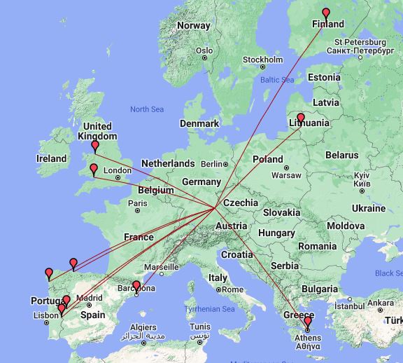
POTA DE-0376 Donau Park

POTA Contacts Map
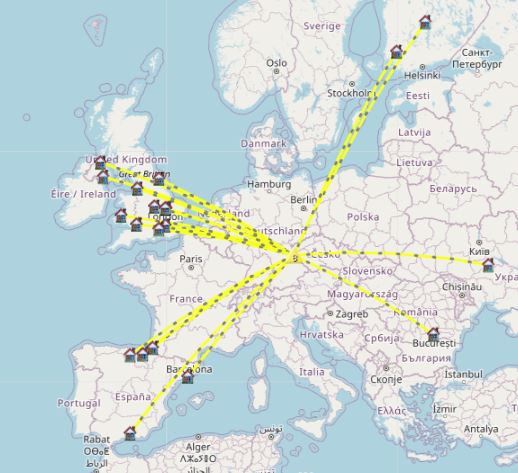
POTA DE-0024 NordlicherOberPfälzerWald NP

POTA Contacts Map

SOTA DM/BM-321 Fahrenberg

SOTA Contacts map
POTA DE-0017 OberpfälzerWald NP

POTA Contacts Map
Conclusions:
- The weather was a problem mainly on the third day, combined with the mis-navigation that was a “bad” day – lesson learned to use the Smartphone map/tracking app when attempting to activate a new summit.
- The Xiegu G90 continues to work surprisingly well even when only using the Komunica Power HF-PRO-2-Plus-T on a mag mount on the car roof. That park-to-park contact with Australia was a highlight of the trip.
73 ’til the next summit/park.

You must be logged in to post a comment.