Preparation:
These two activations were originally planned to be part of my activation two days earlier as they are in the general same area as Falkenstein and Zwolferkopf however they would have been too much and so got left.
With the continuing good weather and increasing threat of a lock-in (where no-one would be allowed to leave their homes) because of the Coronavirus, I decided to go and complete these two summits which are located close to each other. Well, that needs some qualification – they are close “as the crow flies” but getting between them via road is more difficult!
One part of my preparation was to see if I could find a shorter route between them to save me some time. I gave Google Maps™ the task and it came back with a route using farm roads, which as I was to find out later, were only legally accessible by farm or forestry traffic. I had suspected this might be the case and in the event had the car’s Navi pre-programmed for it to take me the long way around using normal roads. It’s an interesting area with small villages or actually hamlets, hidden away down small roads in the hills and valleys and what looks like a wonderful lake to go to one summers day some time to enjoy nature.
In any case, preparation apart from the mapping work was to pack the same equipment as for the previous summits – the X108G plus the Komunica HF-PRO2 and photo tripod plus I also packed the two dipoles and the surveyors tripod and DX-Wire 10m portable mast just in case I decided the effort was worth carrying the extra weight to put up a more effective antenna.
The Activation:
I woke to another nice looking day, loaded the gear into the car and was on the road before 9am. I had deliberately not started too early as these are “relatively” easy summits and as the day goes on the temperatures would rise. I was not looking for any DX stations and as it turned out propagation was poor. This time I was not plagued with closed roads on the journey down and I deliberately avoided the closed road I knew about on the way back.
DL/AL-170 Zwieselberg: It always seems a little bit strange driving to my parking spot for Zweiselberg as the group of houses there have declared independence from the local government authorities (see the first picture in slideshow below). Also, I have to drive up through what is a farmyard between the houses, however, as the sign says, private road use at your own risk, rather than no entry, all seems legal to use it and I have never had any problems. One should watch out for kids who are often playing there though.
After parking in the car park on a bit of a slope, putting the hand brake fully on, leaving the car in gear and putting something under the rear wheel (yes it was that steep a spot). I unpacked the new rucksack containing the radio gear, put the tube containing the Komunica HF-PRO2 antenna on the side of the rucksack and decided to leave the heavy tripod and mast in the car. At this point, you can see how steep the track is and the particular problem here is that the track has been covered with stones to help keep it stable for the farmer’s tractor in winter but for a walker, the stones can easily slip away from you under-foot. Hence the long, steep climb with a heavy rucksack on my back was taken slowly with lots of stops to catch my breath and take some photos of the amazing views. As I approach the holy cross near the summit trig point stone the hut that I remember being there, now has a nice garden with some outside cooking facility added, so it looks like the locals may come up here for their parties.
The cross itself is in a fenced-in enclosure with a long bench and an information table. I set up the antenna at one end of the bench and the rig, in the rucksack on the bench. With my first contact, I was informed that my audio had a problem and it was most likely because of this closeness I think (after all I was standing on the radial wires!). In any case, after moving the radio and battery box a little further away from the antenna, it seems things were fine again.
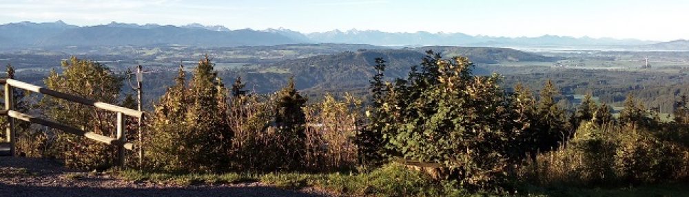
The views were wonderful from Zweiselberg and I would have quite happily simply sat there in the sunshine for a couple of hours, but I was there to qualify the summit, so I’d better get three more contacts into the log. I ended up with 24 contacts in the log before the pile-up came to an end.
Time to pack up and head back down the track to the car and then head off to Senkelekopf, the next summit. After packing the gear into the car I got out the instructions from Google Maps and set off following those instructions but also with the car’s Navi turned on. It wasn’t long until I came to where I was supposed to turn off according to Google – while one could have driven a car down the road, there was a sign stating (as I had expected) that “normal” motor vehicles were not supposed to use the road, only farm or forestry traffic. So I gave up on the instructions printed out from Google Maps and concentrated on following the directions given by the ladies voice in the cars Navigation system. It took over 20 minutes to get to the same car parking spot near a small chapel in Oberlangegg that I remember from the last time I activated this summit.
DL/AL-172 Senkelekopf: From the rough ground where I park my car, it’s a short walk across to the chapel building and from there one follows first the fence up the side of the field to the stile and then the slopes become clear where the tracks go, always heading upwards and a little to the right and eventually you come to what appears to be a farm building (called Senekle Alpe on maps) and alongside it on a small hill to the left is a holy cross, but it is fenced in so that you can’t get to it. Heading off past the building, to the right, the ground rises up to Senkelekopf where I set up my station. This last rise is less than 25 vertical metres so you could set up anywhere on the flatter ground and still be within the activation zone.
Before I started operating from here, it was time for lunch and a chance to sit in the sunshine and admire the views! I was really enjoying these two activations. The climbs at Zweiselberg and Senkelekopf are strenuous but it’s worth it.
This Summit bagged 25 contacts in all. All on 40m SSB and without a re-occurrence of the bad audio problem as on this summit I made sure to not set up on top of the antenna!
Photos:
Zwieselberg:
Seneklekopf:
Equipment:
- Xiegu X108G.
- Photo tripod
- Komunica HF-PRO-2 multi-band HF vertical antenna.
- Battery box (2 x 5000maH hard-case 4S LIPOs).
- Surveyors tripod with DX-wire 10m mast (packed in the car but not used).
- Aerial-51 OCF 40-10m dipole & SOTABeams Band Hopper linked dipole (taken but not used).
- Thick plastic painters sheet.
- Smartphone with PocketRxTx App and USB cable acting as an external display to the rig.
Logs:
DL/AL-170 Zwieselberg:

DL/AL-172 Senkelekopf:

Conclusions:
- The weather was wonderful again! – I can get used to this!
- The “rapid deployment” (lighter) kit appears to work well apart from when I set up too close to the antenna. It’s not as “light” as it needs to be though!
- The two steep climbs exhausted me but the summits were worth the effort.
- It still had some issues with some SOTA chasers being over-eager but nothing like the problems, two days earlier.
- I would have liked to have tried out the speech processor (which I had with me) but with the RF feedback happening on Zweiselberg, I decided better of it and just concentrated on getting the two activations into the log.
73 ’til the next summit!

You must be logged in to post a comment.