This activation was scheduled as I would be in Friedrichshafen for the annual “HAM RADIO Friedrichshafen” event. There are two SOTA summits close to “FN” Höchsten” and “Gehrenberg” the latter being the closer but the former being a “drive-up” summit.
As I wanted to plan this as an early morning activation with the chance of some contacts into VK, Gehrenberg is closer to where I would be staying so it was chosen over Höchsten.
I had my standard rucksack packed with the G90, squid poles, screw-in base etc. in the back of the car, so the plan was for this to be a relatively quick activation on Saturday morning before heading into “HAM RADIO” which opened at 9 am.
The evening before however, I met Glenn VK3YY and Andrew VK3JBL who were over from Australia and said that they had tried to get to Gehrenberg and failed because of road closures due to recent flooding. When they described their route, I was of the opinion that they had used a different approach to the one that I have settled upon over the last few years and to be sure, after the SOTA dinner, I drove my route up to the place I normally park for the summit and the route was open however there were some confusing signs related to the route to a different town and these were not relevant but for non-German readers such as Glenn and Andrew, these might seem like road closed warnings.
That evening I documented the route with pictures and sent this all Glenn and he said that they might try to get to the summit the next morning and we could activate together. There was another reason that Andrew VK3JBL wanted to qualify the 8 point summit and that was because his current SOTA activator points total was at 997 and this would take him over the 1000 points making him a “Mountain Goat”.
The Activation
DM/BW-348 Gehrenberg
On Saturday morning I was awake early and decided to head straight up to Gehrenberg to get set up and if Glenn and Andrew came along, I would have made my 4 contacts and be out of their way. The run-up was the same as the previous evening so I sent a short email to Glenn confirming the road was still open.
Luckily the tracks were not as muddy as I had feared they might be and I was set up and running by a quarter to 7 am using the usual Xiegu G90 and the linked dipole with the 20m link open supported by a 6m telescopic pole in the screw-in sun umbrella base with the ends tied off to some tree trunks.
The first contact in the log was a sked with Ernie VK3DET in Victoria, Australia, after that it was signals from the north – Poland and Finland before another Australian Peter VK3ZPF, who I haven’t talked with for several years and another Polish station and an Italian one finished up the contacts for a valid activation. As I was taking the mast down and packing the radio away, I heard voices and it was Glenn and Andrew coming up the hill, to start their activation and soon after another ham came from another direction to the summit, so this can be a busy summit during the HAM RADIO Friedrichshafen event.
I stayed long enough to see that Andrew qualified the summit and hence earned his Mountain Goat, before heading back into Friedrichshafen to the show.
Photos:
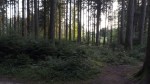
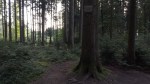
Parking spot and track up to summit
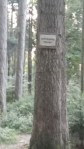
Summit sign
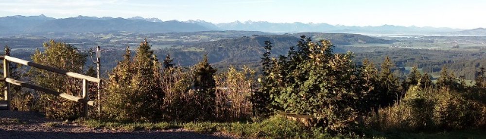
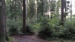
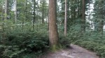
The view around the summit
The view around the summit
The view around the summit
The view around the summit
The view around the summit
The view around the summit
The view around the summit
The view around the summit
The view around the summit
Station
Glenn and Andrew by activation.
Equipment taken:
Mountaintop travelling 40-litre rucksack.
Xiegu G90 radio.
Screw-in sun umbrella base.
6 Metre Lambdahalbe mast.
Komunica Power HF-Pro2-PLUS-T loaded vertical antenna and tripod (not used)
Something seemed wrong with the 20m section of the linked dipole. It could be that I had it too close to the trees and they were de-tuning it but it will need to be tested before the next usage.
It’s a nice feeling to be there when someone achieves Mountain Goat status (I took videos).
As I was attending HAM RADIO 2022 in Friedrichshafen, it is an obvious task to pick up the two easy 8-point summits nearby. On this trip, however, I also planned out some new HEMA summits to activate on my way home.
As well as my now fairly standard rucksack with radio, batteries, antennas and one 6m mast, I also added my large tripod with 10m mast and my old 10Ah battery box into the back of the car with the screw-in mast base support. In this way, I could decide to take out of the car what I thought I would need for each summit and avoid carrying everything to the summit. In the case of the two SOTA summits, I have activated these before and hence know what is the most suitable equipment. The three HEMA summits, however, I have never been to and hence I would need to plan when I arrived at them what I would take with me.
My original plan was to activate the 2 SOTA summits on Saturday evening and leave the three HEMA summits for my afternoon drive home on Sunday as the event effectively closes at lunchtime on Sunday.
As it turned out an appointment clash meant that only one of the SOTA activations was completed on Saturday evening and I decided to drop attending HAM RADIO 2022 on Sunday morning so that I could complete all of the activations.
The Activations
SOTA DM/BW-348 Gehrenberg
This was the Saturday evening (25/6/2022) activation with Chris M0TCH along to activate. He had visited this summit with me back in 2018 but has got more into the swing of SOTA lately and hence was eager to activate both this summit and Höchsten that we had planned also to activate.
We were delayed a little on our departure from the Messe by a ham wanting to talk about something and also when setting up on the summit we had two cyclists as visitors. The end result was that if Chris was to get to his dinner appointment later in the evening, we could not fit Höchsten in. a shame but in my case, I could simply move it to Sunday morning as I had decided not to head into the Messe on Sunday.
After parking outside the forest at Gehrenberg, the walk up to the summit took a good 10 minutes and set up (with the interruptions) took about half an hour. I had Chris start on HF to get his needed four contacts and then he went a little bit away to try to get further contacts on 2m FM using a newly purchased larger antenna on his HT.
The equipment I used on this summit was the Xiegu G90 and the linked dipole on my lambdahalbe 6-metre pole supported with my sun umbrella screw-in base. Something to note on this summit is that there are tracks arriving at it from multiple directions so installing an inverted-V dipole antenna you need to make sure the wire is high enough as it crosses the track if some racing cyclist is not going to run into it!
As time was marching on and we thought we “might” get Höchsten in as well we kept contacts to a minimum and then packed everything up again. On the walk back to the car, however, doing some calculations it was obvious that we could not fit in the second activation and so we headed back into Friedrichshafen.
This slideshow requires JavaScript.
SOTA DM/BW-856 Höchsten
This summit is a fairly recent addition to SOTA and was added when Aacheck was removed. It is a really easy 8-point summit with its own car park on the summit. On Sunday morning I was there, unpacked the gear and set up – this time using the 10 metre DX-Wire mini-mast supported by my large surveyor’s tripod as there is plenty of open space on this summit. This summit, like Gehrenberg, gets very busy around the time of the HAM RADIO event in Friedrichshafen as most SOTA activators can’t resist the easy 8 points for both of the summits.
After working fourteen stations on forty metres, I packed up so that I could head to the first of my new HEMA Summits of the day. On returning to the car park Christian DL3EC came up to say hello. He had been working on 20m SSB from another field and we had not caused each other any interference at all.
The weather was just starting to warm up, a sign of what was to come.
This slideshow requires JavaScript.
HEMA DL/HBW-018 Galgenberg
Galgenberg is the location of a microwave relay station between Vogt and Wetzisreute (to the east of Ravensberg) and once you have parked in the large pull-off car park, you need to cross the L325 road and head up the track that runs around the hill to climb at a reasonable rate for the radio service vehicles to get up. Once you reach the top, there is a nice grassy area behind the brick building at the top of the tower that fits well for putting up an antenna.
Knowing from the map that I would have the climb, I had opted to take the same equipment in the rucksack to this summit as I had used at Gehrenberg the night before – the Xiegu G90, 6m mast and linked dipole. The day had now changed to be hot and humid with lots of annoying flies, some of which were biting me, so between contacts, I was swatting the little so-and-so’s!
As well as the weather changing, the band conditions also changed with very deep QSB and of course – as with every weekend QRM from deaf contest stations. Spotting on the HEMA cluster does not bring the same rush of callers as when activating a SOTA summit so I was searching around and calling CQ a lot from this summit. One of the stations that took pity on my long CQ calls with no answer was the main special event station out of England for the Queen’s platinum jubilee – GB70E. That was a nice surprise.
After the long drive up from Höchsten, it was getting near noon and I was getting hungry. So, after I had worked eight stations across 40 & 20m from this location, I packed up and headed back down to the car, to set off to the next HEMA summit.
This slideshow requires JavaScript.
HEMA DL/HBW-035 Lutascher (NoName)
The reason I have written “NoName” in brackets is that is what this summit was called in the HEMA database at the time that I activated it. When I surveyed this region I could find a name for the summit on any of the official, detailed maps. I have now asked for the name to be changed in the database.
On arriving at this summit and parking outside of the forest, it was getting rather warm. I had not found anywhere along the way to grab something to eat and so, again I hoped for a quick activation and then to get on the road again. it was not to be so. the bands had got even worse than before.
This is an interesting summit and the actual highest point is in fact on top of a grass bank covering the water tank that supplies the local farms. There is a LOT of cycling activity around here – it seems this location south of Bad Wurzach and through “Waldfeld” is a favourite for the cyclists.
Once I got past a barking dog, (who was more afraid than aggressive) whose owner came along 5 minutes later looking for “Sara” (on a bicycle of course) – I told her the direction the dog had gone, I could climb the grass bank on to the water supply system and set up the gear (which was the same as used on Galgenberg).
This was another summit where getting contacts was difficult because of the band conditions but I did manage six contacts on 20m before the 4Ah LifePO4 battery finally dropped below the voltage needed by the G90 and set off an alarm tone. no issues, I also had my 4 Ah LiHV battery with me but even after connecting that no further contacts were possible, so – as it was now even hotter than before, I packed up and headed back to the car.
I considered whether to drop the last planned summit but in the end decided that as it was on my direct route home, I should be able to manage it.
This slideshow requires JavaScript.
HEMA DL/HBW-039 Galgenhöfe
This summit is just off the L309 road between Seibranz and Unterzeil. The area is shown on maps as Galgenhöfle however when you arrive the signs don’t have the L in the name. You will need to check the coordinates on the map as you don’t want to go to the hamlet of Galgenhöfe rather you need to go into the forest directly on the other side of the L309 road. There is a large gate and cattle grid. I parked just before that as the rest of the track is only for forestry vehicles’ use. From that point, it is about a 7-minute walk on a track that goes off to the left and you will see when you get to the top of the rise. Some scrambling is needed over branches and the like on the floor to get to a reasonably open area, where I again set up the G90 and linked dipole. At this summit, it took me 20 minutes to get the required 4 contacts. two on 40 metres and two on 20 metres. The last contact of the day was with Christian DL3EC who I bumped into at Höchsten. He was now on a different SOTA summit – DL/AL-146 Sonneneck, after also visiting DM/BW-348 Gehrenberg on the way.
This slideshow requires JavaScript.
Equipment used:
Mountaintop travelling 40-litre rucksack.
Xiegu G90.
Komunica Power HF-Pro2-PLUS-T loaded vertical antenna. (not used)
Modified mini photo tripod with clip-on radials (not used)
Lamdahalbe 6m mini-mast (x2 – one spare).
DX-Wire 10m travel mast.
Surveyors tripod.
Screw-in sun umbrella support.
SotaBeams linked dipole.
SotaBeams random length end-fed antenna (not used)
4 Ah Eremit LifePO4 battery.
Battery box (2 x 5000maH hard-case 4S LIPOs) (just as 2nd backup – not used).
4000maH LiHV battery.
Painters thick plastic sheet.
Gardeners nealing pad.
Lightweight headphones.
Smartphone to spot on either SOTA or HEMA.
Logs:
SOTA
DM/BW-348 Gehrenberg (25/6/22)
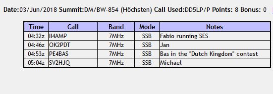
DM/BW-854 Höchsten (26/6/22)
HEMA
DL/HBW-018 Galgenberg (26/6/22)
DL/HBW-035 Lutascher (26/6/22)
DL/HBW-039 Galgenhöfe (26/6/22)
Conclusions:
The common knowledge is not to activate on a weekend (because of contest QRM) – in this case, that made 40 metres difficult however on 20m at least some contesters obey the IARU rules and don’t use frequencies above 14300 kHz. It’s a shame the band was all over the place.
The new LifePO4 battery performed well powering four of the five activations.
After its total re-build, the linked dipole appears to be working fine.
After multiple cancellations on a weather basis with incorrect forecasts, I was determined that two days after the official start of summer, I was going to get to these two eight pointer summits and get them activated! These two summits are the two nearest to Friedrichshafen that most SOTA activators visiting Ham Radio Friedrichshafen will somehow manage to fit into their trips. This year with COVID-19 restrictions the government ordered the cancellation of all large venue events until at least the end of August. Ham Radio was scheduled for June 26-28th and so was cancelled for this year. I was actually going to activate the summits in what would have been the week before Ham Radio Friedrichshafen.
The first of the two Summits – Höchsten DM/BW-854 is a fairly recent addition to the SOTA summits list and was added a little while after two lower summits were removed. It is the location for several TV, radio and microwave towers and is a true “drive-on” summit, with its own car park on the top from where you can walk into open grassed areas to set-up the gear or walk over and visit the Rondell which marks the exact summit.
As this is an open summit with no trees I could plan to simply use the light kit, with the X108G driving the Komunica HF-PRO2 loaded vertical on a photo tripod. This could also be an opportunity to try out a new, lighter and smaller tripod for which I have re-calibrated my table of HF-PRO2 settings. However, this wide-open grassed area also invites the use of the large surveyor’s tripod, 10m mast and either the Aerial-51 OCF dipole or the SOTABeam’s band hopper linked dipole. On my last visit here, I actually set-up the VP2E antenna, so you can see Höchsten has plenty of room for antennas! Given the drive-up nature of the summit, it lends itself to packing all options into the car and then to decide when I arrive what I will use.
The second planned summit – DM/BW-348 Gehrenberg is a summit in a forest with lots of trees, so using a vertical in this environment would be a waste of time. So in this case, despite the relatively long walk in from my parking spot on the side of the road before the “forestry access only” sign, I would have to take the heavier equipment set-up including the large tripod and 10 metre mast.
The car was packed the day before for a pre-8am start for what was expected to be a 2-hour drive to the first summit.
The Activations:
I awoke to sunshine and no rain. After the preceding couple of weeks, this was a change. I hoped the weather would stay fine as I left at 7:50am with the car Navi(GPS) saying to expect a 1hr 40-minute drive, so a little time possibly won as there were no traffic problems en-route, even the standard roadworks on the autobahn around Memmingen didn’t cause an excessive delay and I was soon off the autobahn onto the country roads that would form over half of my journey. This was not to be the section of the journey which caused me problems and I arrived at Höchsten around a quarter to 10am and was set-up and operational by 10am (0800 UTC).
DM/BW-854 Höchsten:
On arriving at the summit, I sent Ernie VK3DET in Australia a note in the hope that we might just still have a chance of a contact however the sun had already set in Victoria, Australia and the HF bands gone to sleep. Despite a couple of hopeful calls, there was no DX contact this time. This was not a surprise – I would have needed to be at the summit an hour earlier for any real chance and at the moment, late evening European time rather than early morning is when the EU-VK contacts are being made.
Given the closeness to the car and the open flat location, I decided to use the Aerial-51 OCF antenna atop the 10m mast supported by my surveyor’s tripod. Although I took the amplifier with me to my operation spot, I never bothered connecting it in and just ran with the 20w from the X108G. As it was sunny, I was happy that my solution using a SmartPhone as an external display works so reliably as the display on the X108G itself would have been totally invisible in this light.
Using the X108G on 20 watts output, the 10m mast and the Aerial-51 OCF dipole, I managed 17 contacts on 40m SSB including 3 S2S contacts and 8 contacts on 20m SSB. I shut down and started packing away three times, only to see other activators on, who I might get an S2S with. This activation was exactly 45 minutes long and when the calls dried up, I decided to pack-up as some winds had arrived on the summit and I’d also rather have some time in hand for getting to the next summit.
DM/BW-348 Gehrenberg: The trip to this summit ALWAYS seems to cause me problems! I had not approached this summit from Höchsten before, so the roads were a little different and the most direct route was closed because of the total re-building of one road (this was to provide an even bigger problem later). My Navi(GPS) does not understand when I don’t follow the given route and keeps trying to take me back towards the blockage. This is the standard GPS installed by the car manufacturer, in previous cars, where I had added cheap Chinese aftermarket Navis/Car multimedia devices, they realised when I took a different route and recalculated the guidance – not so with this Peugeot unit! In any case, I knew how to get to Gehrenberg from Markdorf and a route to Markdorf was still signposted, so I followed that and headed to Gehrenberg from there. This probably added 30 minutes to the direct route, but I got there and found my usual parking spot.
I now did a little selective packing into my rucksack. As I hadn’t needed the amplifier on the last summit, it and its box of cables/controller got left in the car as did the photo-tripod and the HF-PRO2 antenna but everything else was to come with me. It was now getting warm, so I packed my waterproof jacket into the rucksack rather than wearing it and with my rucksack on my back and the surveyor’s tripod containing the 10m mast, over my shoulder, I set off up the track into the forest where the Gehrenberg summit is located. (I have posted a short video of this walk on YouTube – link is below).
On arriving on the summit and catching my breath, I put up the tripod and mast and while the Aerial-51 OCF had worked fine at Höchsten, I decided to put that up again. As you’ll see at the very end of the video – this didn’t end up being the antenna that I used from Gehrenberg as it broke, right at the balun/feed point. Luckily I had brought my SOTABeams Band hopper antenna along as a backup and after taking down and packing away the broken antenna, I put this other one up, with it set initially for 20m as it looked like there was more activity on that band over 40m. Unfortunately while taking the first antenna down, the DX-Wire 10m mini-mast decided to collapse rather than lower smoothly, jamming some sections inside it a further cracking an already cracked section.
After the delays of both getting lost driving here and the first antenna breaking, I was eager to get some calls in the log. To add to this the sky had started to turn grey (nothing actually came- it just threatened in the end). From this summit using the X108G and SOTABeams band-hopper at about 8.5 metres. I worked 12 stations on 20m and then switched over to 40m to add another six – two of which were Summit-to-Summit contacts.
Once the contacts dried up again, I decided to call it a day, took the mast first down as far as I could and then took it apart to un-jam, the jammed section inside and empty out the pieces of broken fibreglass. Then it was time to head back to the car – here is the APRS track that I made from the car to the summit – actually it’s two tracks as I turned on tracking in both directions.
Once back at the car, and everything packed, it should just be an easy trip home, right? Wrong? I set the Navi(GPS) for my home address and followed its directions. Unfortunately, that same total road closure that had meant I had to divert on the way to Gehrenberg, was an integral part of the route home and as this Navi doesn’t like you not to follow directions and will not re-calculate a route, but rather re-routes you constantly back to the same closed road and … I had joined this important road AFTER where the diversion had been signposted, so I was on my own and my only option was to head back, past Gehrenberg again to Markdorf, where I knew I could pick up another major road and from there head back onto my home route. So 30 minutes wasted and being a little later, the traffic was now busier. So I had a 1-hour 40-minute journey to the region and a 2-hour 20-minute journey home. I suppose this averages to the 2 x 2-hour trips that I had planned overall …
Portable 70w amplifier and switching cables (not used).
Surveyors tripod and 10m mast.
HAMA Photo Tripod (not used).
Komunica Power HF-PRO2 loaded vertical (not used).
Aerial-51 OCF dipole (used at Höchsten).
SOTABeams Band-hopper (used at Gehrenberg).
Battery box (2 x 5000maH hard-case 4S LIPOs).
Thick Painters plastic sheet.
Lightweight headphones.
Smartphone with PocketRxTx App and USB cable acting as an external display to the rig.
Logs:
DM/BW-854 Höchsten:
DM/BW-348 Gehrenberg:
Conclusions:
From the weather forecasts over the last two weeks, 80% were inaccurate – one has to simply go and hope the weather will be OK. This time it was, there was some wind on Höchsten and some dark clouds approaching on Genrenberg but overall the weather was wonderful for a change!
The fact that I carried a “reserve” antenna to Gehrenberg paid off when the planned antenna broke (now repaired). Had I not had the spare with me, I ‘might’ have been able to do a temporary fix on the Aerial-51 antenna, but whether it would have held…
The filter setting changing problem now seems to be fixed after replacing the CMOS battery again in the X108G.
The 1:1 balun at the feed point on the SOTABeams band hopper linked dipole feels fragile and since returning home, I have now fastened this to a far more solid “T-piece”, so I think it will now be strong enough.
I took the amplifier along in case there was a chance of a contact into VK but decided not to use it. The additional cables and switch unit, make it cumbersome to set-up unless really needed. The 20w from the X108G even without a speech compressor or amplifier was getting good reports. (I have yet to test the DYC-817 external speech processor from a summit, but again, it is more cables and another device that can go wrong, so except for a situation where I want to drag the last small piece of signal out of the station, it probably isn’t worth the extra complexity).
Since the previous year when only one summit was easily reachable from Friedrichshafen following the removal of two summits from the SOTA scheme, a new SOTA Summit “Hoechsten” has been added making it relatively easy to activate two 8 points summits while attending the Ham Radio Hamfest in Friedrichshafen. To this end I booked a hotel about 15 minutes drive away from the new summit. The original plan was to activate both summits on Friday afternoon prior to the annual SOTA Dinner that I had arranged again, However the weather forecasts were predicting serious rain on Friday, so I changed my activation plans to Sunday morning. In the end NO rain came and all three days were sunny and warm. My intention was to have group activations of both summits, with S2S contacts between them however when I saw the weather, I suggested all make their own plans. Several stuck with Friday afternoon and enjoyed some nice weather and lots of contacts. Some planned to activate at least Hoechsten prior to or after the Ham Radio event as they were taking a longer holiday in the area.
My revised plan for Sunday morning was adjusted to fit in with some of the ICQ Podcast team who I was working with to get interviews for the podcast, so they could also take a look at a SOTA activation. The final plan was that I would activate Hoechsten before breakfast on Sunday, then return to the hotel, have breakfast and check-out, then go and pick the guys up and head up to Gehrenberg and when finished go back to Ham radio for a couple of last interviews and then take and drop them off either at the ferry to Switzerland or Memmingen airport. That is finally what came about.
The Locations:
Hoechsten was about 15 minutes drive from my hotel near Wilhelmsdorf and the closest hamlet is Glashuetten. From the car park to the summit is an easy 5 minutes walk up to “Aussichtspunkt Hoechsten” (in fact not to block the lookout point I went past it to a larger grassed area behind the lookout).
Gehrenberg is a few km north of Markdorf and is approached best from a small road just on the southern end of the village of Harresheim (make a note of this as every Navi/GPS I have used has taken me to the wrong location!). It’s about a 10-15 minute walk from where no motor vehicles are allowed, up to the summit. I usually activate near the base of the radio tower (which well within the AZ) but this time I decided to follow the track up through the forest to the actual summit.
The Activations:
Hoechsten.
I woke before the alarm went off and was underway to the summit before 6am. The navi takes a while to lock onto satellites but I didn’t want to wait with the engine running in the hotel car park and wake the other guests up, so I set off in the rough direction that I expected the summit to be. Once the Navi locked in its satellites, I was one village past the turn off I needed, so I had to turn around and head back. From there on the Navi diligently lead me up the (small) roads to Hoechsten and I came out at the road junction across from the car park. I could just see the small bandstand like lookout building through the trees. Not as obvious as I was expecting it to be, but sign-posted from the car park. So I unpacked the usual two SOTA bags and the Surveyors tripod which was a new addition to the kit. It stands about 1m 80cm high, has spikes on the legs and a hole through the mounting plate where a theodolite would normally be mounted. I have also added a pass-thru SO-239 double socket for use with mobile HF whips but today it would act as a simple support for my fibreglass fishing pole meaning I would not need to seek out a convenient fence post or tree to fasten the mast to and can position it where I want it.
I was set up and calling CQ SOTA by 6:15 AM but unfortunately with no response. Despite putting up spots for 40m and 20m on SOTAWatch, I was getting no calls, so I decided to tune around to see if any “normal” stations would be willing to talk to me. Several I called either couldn’t hear me or simply ignored me as I wasn’t “DX”. I was glad when Fabio II4AMP cheerfully came back to me and gave me a “True 5-9” he was well over 5/9. So it seems the gear was working OK, after some more attempts at calling what turned out to be contest stations and another spot Jan OK2PDT a very active SOTA chaser came back to me but it seems he was the ONLY SOTA chaser who was out of bed that early on a Sunday morning as the other two needed contacts came from a contest station and a friendly Greek station just looking for contacts.
With the delay in getting the minimum 4 contacts (which took me over half an hour), I was now going to be tight on my schedule for the rest of the morning, so it was a quick pack-up (the new tripod being quick to set-up and take down helped somewhat), back to the car and back to the hotel for breakfast which started at 7:30am. I arrived back at the hotel at 7:29am, went up and brought my case down into the car and then went to breakfast. At 8am I was checking out and off to pick up the other guys from near Friedrichshafen.
Gehrenberg.
I arrived a few minutes earlier than planned into Burg and the extra time was not a bad situation as Colin M6BOY and Chris M0TCH (the ICQ Podcast guys) were already just about ready to go. So off we went with the Navi now set to Gehrenberg. All was well until in Markdorf (near to the summit) I missed one small turn off and the Navi said “re-calculating route”. In hindsight it would have been best to turn around and return to the exit as the Navi now took us to a road at the other side of the summit from where access is not possible. I recognised this and after 5 minutes referring to maps on smart phones, we were off again to hopefully go around the end of the hill, to the correct road towards the summit. This was not to be our day as we went past the exit, which I realised as we came to the hotel that I had used last year for the SOTA dinner. Another stop and look at maps to see why we had missed the exit. The key point is that the small road needed is at the very southern end of the village of Harresheim, whereas the maps were showing it as outside of the village. Another thing to look for is signs for “Sturzhof” this is a building just past the corner where the track goes off up to the summit. While there is no red circle sign, there IS a sign that says only Forestry vehicles are allowed past this point. Last year (and I suspect this year as well) several cars drove up the track all the way to within 50 metres of the summit. I normally set up on some flat land near the bottom of the radio tower but as Luc ON7DQ told me last year that a few more minutes up the road, there was a track up to the actual marked summit, I decided to we’d check that out. It took about 15 minutes from where I parked the car just off the road to the summit. It is quite a steep track but with two extra willing pairs of hands to carry some of the gear, it was a reasonable walk up to the summit. The summit is totally forested, so no interesting views from it and it is also on a favorite track for cyclists, so I had to be careful where I strung the dipole out to! We were at the summit just before 10am.
The new tripod again proved a great advantage as there were no obvious places to strap the mast to and with the tripod I could position the antenna to be out of harms way for the cyclists (and my antenna). The radio and its battery box were placed on the large stone on the summit and the antenna connected. On 40m there was an S7-S9 noise level – I suspect coming from the microwave radio link tower although there were reports of the bands being noisy as a lot of solar debris was hitting the Earth’s atmosphere at the time. In any case after some spots to the SOTAWatch website and tuning around I managed a few contacts on 40m. these would have been enough to get the points for activating the summit but as Chris was recording the activation for a possible feature on ICQ Podcast I thought I should try for some more and switching to 20 metres immediately dropped the noise level. It was at this point however that I saw that the SWR was over 2:1 on the antenna, which normally sits between 1.2 & 1.5:1. I’ll need to investigate that. In any case I managed to get a good run of contacts going and at the end we worked a total of 18 stations across Europe.
This again had taken more time than expected and after packing up we got back to the car at about 11:00 am and then drove back to the guys apartment to pick up their luggage and the 4th. member of the team Conor, Colin’s son. So by the time we got to the show again it was 11:30 and we needed to leave for the airport at the latest at 1pm, so there would not be a lot of time to do anything. As we went into the halls about 25% of the stalls had either already or were starting to pack up in any case. One last interview went into the can and we were ready to leave.
A very busy day but well worth it.
Photos:
1. DM/BW-854 Hoechsten.
This slideshow requires JavaScript.
2. DM/BW-348 Gehrenberg.
This slideshow requires JavaScript.
Equipment:
Xiegu X108-G “outdoor” version.
Laptop tilt stand.
Surveyors tripod.
Aerial-51 OCF dipole.
LambdaHalbe 6m telescopic fishing pole.
Battery box with 2 x 5Ah 4S LIPOs and regulator to reduce voltage to 13.8v.
Logs:
1. DM/BW-854 Hoechsten.
2. DM/BW-348 Gehrenberg.
Conclusions & actions:
I may have a problem on the Aerial-51 dipole which I will need to investigate for a bad connection causing that 2:1 SWR.
The surveyors tripod was a real success but I may add a small plug or plate to reduce the size of the hole in its centre.
Shade is definitely what is needed to make the display on the X108-G visible. When Chris stood in the way of the sun, the display was perfectly readable. I ordered a small sunshade for the rig (really meant for a camera LCD screen) which arrived while I was away, so I will try that to see if it gives me a solution.
I’ll try to remember NOT to use the Navi, the next time I am heading to Gehrenberg!


You must be logged in to post a comment.