DD5LP/P – September 13-14 2022 – HEMA DL/HAL-033 & SOTA DL/AL-181 Burgkranzegger Horn and SOTA DL/AL-167 Falkenstein.

Preparation:

As part of my short holiday away from home, I had hoped to activate some higher HEMA and SOTA summits that I had not activated before however as it turned out with uncertain weather and the fact that my wife and the dog wanted to come along, I decided on some simpler summits mixed with some sightseeing around the southern part of Allgau, Bavaria.

As it was to turn out, this was a good decision and we had two enjoyable days and one where it rained all day and we came home early. At this time of year that was probably the best, we could have hoped for. 

Preparation for the trip was limited by the space available as the rear area where I would normally load all of my radio gear was taken up by our dog “Bonnie” meaning all luggage had to fit in our small car on the rear seat.

So the activation equipment was limited to what could go into or be attached to the side of, my 40-litre rucksack. I even chose not to take the lithium battery charges to recharge batteries overnight and rather took three battery packs of different sizes with the expectation that I would not drain them all. This of course added to the weight of the rucksack, as did the screw-in mast base attached to its side.

No experiments with antennas, I would take the linked dipole and the 6m mast with the HF-PRO2 loaded HF whip and its small tripod inside the rucksack as the backup option (which I needed on the second summit).

The Activations

As the weather looked fine, it was decided to fit in one activation en-route to our hotel.

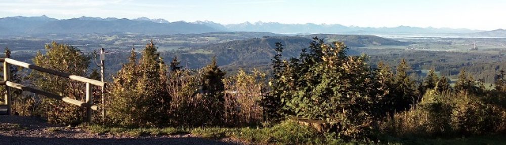
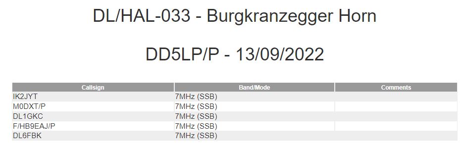
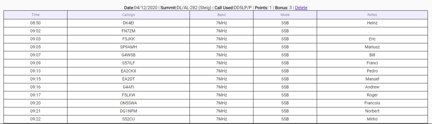
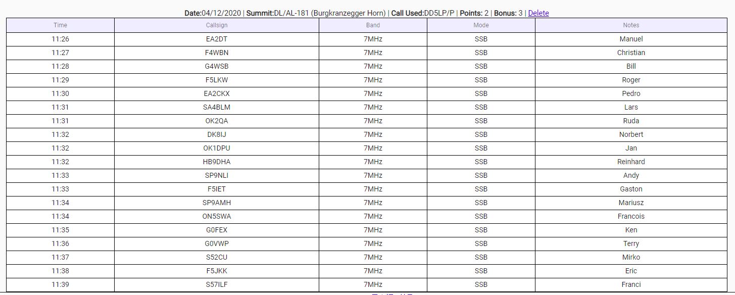
Burgkranzegger Horn – HEMA DL/HAL-033 and SOTA DL/AL-181.

This is a summit with not too difficult access – especially in late summer (the last time that I activated it was in winter and a big problem was fighting through the deep snow as no track was obvious). The summit itself has an open area where the dog could entertain itself. The reason that this summit is in both the HEMA and SOTA schemes is historical and while its prominence is just 125m it fits nicely into the HEMA range of 100-150m while being well under the SOTA 150m minimum.

On arriving at the parking spot at the clinic on the outskirts of Mittleberg village, the weather was fine and we all three set off up the track. Unfortunately, my wife was unable to complete the last part of the climb (she got over 85% of the way there) but rather than risk anything, she said after sitting and taking in the views for a while, she would start off slowly back down, with the dog and wait for me at the car. I continued on to the large telegraph pole sized holy cross on the summit and started to set up on the bench below it. Before I could get set up 5 cyclists arrived, they were doing a tour around the whole of Allgau and were interested in knowing what I was doing. I gave them one of my leaflets in german about “what is amateur radio” and realised that I had forgotten to re-stock my supply so I would not have any more brochures should other visitors happen by – which they did. A younger couple arrived about 20 minutes later and showed interest and so I broke off operations to explain to them what our wonderful hobby is all about.

At some point between the visitors, I managed to get enough contacts to activate the summit. It was very clear however that there is a far smaller following for HEMA than for SOTA. Indeed I think all of my HEMA contacts were people who just happened to find me on 40 metres, not people who had seen my spot on the HEMA website.

SOTA was the usual pile-up following just one spot and a couple of CQ calls.

One thing is for sure, the radio and linked-dipole did their usual sterling service with lots of good reports and in SOTA we do tend to give real reports.

After 45 minutes on the summit, it was time to pack up and head back down to the car park where my wife and dog would be waiting. As I had however texted to say that I was packing up, by the time I was halfway down the steepest part, I could hear the barks of a dog that I recognised and when I finally got down onto the level track, it wasn’t long before I found my wife and dog waiting for me on a sheltered bank under a tree. They had set off to meet me halfway. 

 That was the end of activations on Tuesday, it was now time to head to the apartment hotel in Pfronten and en route buy some supplies at a supermarket. Once we got settled in and went out for an evening meal, the discussion was about what I would do on  Wednesday. Whether I would go off alone to a higher summit or do something easy again.

The weather was looking like it would “hold out” until at least Wednesday afternoon and after some thought, we agreed that we would visit the local farmers market first thing, then head on up to Falkenstein followed by a tourists visit to Fussen about 30 minutes away.

SOTA DL/AL-167 Falkenstein.

This is a summit that I have activated several times (but not this year as yet). It has a quirky one-way private road that opens one-way at times related to minutes past and before the hour. (to be safe there are also traffic lights) so a bit of bad timing on arrival and you might have to wait 20 minutes before you can drive up the road, once you have bought your €4 ticket for use of the road.

We started Wednesday with a rather disappointing weekly market in Pfronten with just two stalls there, so we grabbed breakfast at a cafe and then headed off to the start of the private rod up to Falkenstein, arriving at the start of the road as it closed to allow those at the castle to drive down. No problems we had enough time.

Falkenstein is the highest castle ruins in Germany and was the last of the famous King Ludwig II’s castles and was going to be his base for hunting in the surrounding mountains however he drowned under suspicious circumstances in Starnberg Lake before it could be finished. 

The walk from the car park takes you past a 4-star hotel with expensive luxury cars parked outside, belonging to the hotel’s guests. After what was already a steep walk up the road, the last section is a series of natural and manmade steps up to the ruins themselves. I was glad to see the message that the ruins are open at the bottom of this last climb. Both my wife and dog were determined to get to the ruins to be with me this time while I was operating. It was a fairly hard climb but the views from the top reward you and my wife was very impressed. There was a hefty wind coming up, so I would need to get set up and complete the activation before any bad weather arrived. So I went to the gate to the inside of the ruins, which has a sturdy platform with solid steps up its two levels and even has a round wooden table on the top level – ideal to set the radio up on. The gate was padlocked shut. Whoever put the sign to the ruins being open at the start of the last climb was having a laugh at our expense now!

The problem now is that although there is room inside the ruins to set up the 6-metre mast and linked dipole, outside there is not. So after carrying the bigger antenna and mast and support up all those steps, I had to revert to my backup antenna – the Komunica HF-PRO2 loaded vertical whip on my small photo tripod and with my homemade radial wires. Thankfully once I got set up, this antenna performed like a champion on both 40 & 20m (it actually covers from 80m through to 70cm).  Despite being close to the ruin’s walls contacts were made from around Europe with good signal reports.

 Just as importantly, the dog had settled herself down and my wife was able to sit on a stone seat (of sorts) and enjoy the views and fresh air.

Once the callers dried up, I was able to pack up and we headed back to the car park to wait for the traffic light system to tell us that we could go back down the single-lane road. we then had a nice afternoon looking through the old town of Fussen before returning back to the hotel and heading out to a closer (and better) restaurant than the night before, just as the heavy rain started.

Thursday was literally a wash-out but we had had two great days and activated a couple of nice summits – a low-stress holiday.

 Photos:

Burgkranzegger Horn

This slideshow requires JavaScript.

Falkenstein

This slideshow requires JavaScript.

Equipment used:

  • Mountaintop travelling 40-litre rucksack.
  • Xiegu G90.
  • Komunica Power HF-Pro2-PLUS-T loaded vertical antenna. (used on Falkenstein)
  • Modified mini photo tripod with clip-on radials (used of Falkenstein)
  • Lamdahalbe 6m mini-mast (used on Bergkranzegger Horn).
  • Screw-in sun umbrella support(used on Bergkranzegger Horn).
  • SotaBeams linked dipole(used on Bergkranzegger Horn).
  • Battery box (2 x 5000maH hard-case 4S LIPOs) .
  • 4000maH LiHV battery (not used).
  • 4 Ah LifePO4 Eremit battery.
  • Painters thick plastic sheet.
  • Lightweight headphones.
  • Smartphone to spot and back-channel comms. 

Logs:

Burgkranzegger Horn

HEMA DL/HAL-033 

SOTA DL/AL-181

Falkenstein  SOTA DL/AL-167

Conclusions:

  • Despite the uncertain weather it was possible to have a low-stress and an enjoyable couple of days including some summit activations.
  • The HF-PRO2 on its small tripod worked very well and I wonder if I would have made any more contacts with the linked dipole on its 6-metre mast had I been able to put it up at Falkenstein.

73 ’til the next summit.


Advertisement

DD5LP/P – December 4th 2020 – DL/AL-282 Steig, DL/AL-181 Burgkranzegger Horn & DL/AL-271 “Auf Dem Falken” (Falkenstein).

Preparation:

As the situation with a possible stronger COVID-19 lockdown has still not been clarified, I decided that once December 1st. came along I would try to get out and activate some summits that have a winter bonus that will run out at the end of December (or rather will be reset as it will then be the 2021 winter bonus). My preference would be a couple of higher height and higher scoring summits which I have not activated at the start of the year before the early year bonuses stopped. Unfortunately, these summits need a ski lift for any practical activation and the ski-lifts are now cancelled until at least January 10th. Not that the lifts themselves are dangerous but the government is doing everything that it can, short of announcing and official “stay home” order, to stop people going on winter holidays and creating “super-spreader” centres for the COVID-19 virus.

I had had Steig on my list as outstanding for some time, but it’s hardly a “local” summit with at least a 90-minute drive there. I looked at other summits that I already knew that I could perhaps team it up with but all were too far away, more looking at other summits within 30 minutes drive of the car park for Steig I found these two, which I had never activated before. One had a write-up that suggested it was a straight forward walk to the summit (it wasn’t and I wonder if the other activator actually mistook where the summit was? Either that or a walk-in summer is somewhat easier than in sub-zero temperatures through snow). Bet that is it may, these were the three summits I chose and the plan was to be on Falkenstein at the right time for an S2S into Arizona, USA (something, that with the state of the bands was not to come to fruition). 

Given the unknown nature of two of the summits and the long walk into the first summit, I decided to plan to use my smaller configuration – one medium-sized rucksack with everything (rig, antenna, tripod) packed inside it. I also put a second rucksack in the car containing the portable 100W amplifier, 6 metre FG mast and 4 different wire antennas in case the bands were looking good on the first two summits and having the extra gain on the third summit may make the S2S into the US a possibility. In fact, the bands were not good, so the extra equipment stayed in the back of the car the whole time and in fact, on Falkenstein (“Auf Dem Falken”) there is no space for any antenna other than the tripod-mounted vertical antenna.

With all equipment pre-packed in the car the previous evening, I was ready for an 8 am departure on Friday.

The Activations

Temps varied I guess from -3 to +3°C over the day.

Steig

The first summit (DL/AL-282 Steig), is in the middle of a forest and the final climb changes each time as it depends how the foresters have taken their tractor in to harvest the trees. This time compared to last time it was a diagonal route that brought me to the summit. After setting up the first call was from DK4EI who said the audio was breaking up and he thought it was RF getting into it. He spent 15 minutes with me trying to find it without any change. He even made and played a recording back. I decided to try to work another 3 stations to at least claim one summit and then head home. Strangely even when asked none of the following 10 contacts complained about my audio,  but several commented on the QRM from another station a couple of kHz off – I wonder if that was the problem all the time? It sounded a bit like OTHR radar or something industrial like that.

Needless to say, I was unsure whether there was a real problem or not, however, after driving down over 90 minutes from home, I decided to head to the next summit and see how I go.

Burgkranzegger Horn

The second summit (DL/AL-181 Burgkranzeggerhorn) was OK but a lot longer climb than I had expected from the write-up that I read (or perhaps that op had never got to the real summit? (there are three summit crosses on the route! I checked with a local that I was in the right place before setting up, to be sure).

The summit is west from Oy-Mittleberg and the easiest way to find the path is to park at the rehabilitation clinic. By the way, this small town is a little way away from the normal routes and is certainly a hill walking centre with several nice hotels and cafes in the town (all closed because of Corona) and some sports clothing and other “touristy” shops.

Looking at a hiking map, there are clear tracks shown up to the summit – unfortunately apart from the first one, the others are all covered in snow and not visible however there are a few points to follow – a small holy cross near to a large wooden hut across and up a meadow is the start. There is also a signpost at this point. From there a larger holy cross can be seen – that’s the next point to reach up the hill. from there, the really large (telegraph pole sized) holy cross at the top of the hill is visible and this part of the climb has the best views back over the valley – really amazing views – there’s a reason this is a recreation area. The hard work to get up the hill is worth it for the views. A local couple was ahead of me and took the bench seat at the bottom of the cross, so I laid out once more, my painters sheet on a flat piece of ground a few metres away. This couple confirmed that this was indeed the Burgkranzegger Horn.

After setting up the equipment and taking a few minutes to explain what I was doing .. the contacts came in without problems and without any mention of corrupted audio. So indeed it looks like the problem at the previous summit came from QRM, not from my system! OK, as I was starting to get cold, it was time to pack-up and head back down the way I came, back to the “Reha” (re-habilitation) clinic, not down the main track which leads back into the town of Oy-Mettleberg itself. Climbing down the steep fields while not seeing what was under the snow was more of a challenge than coming up. I suspect this summit will be easier to access when the actual track can be seen!  

Auf Dem Falken (Falkenstein)

Another thirty minutes should have got me to the car park for the third summit (DL/AL-271 Auf Der Falken) which should be called Falkenstein in the SOTA database, there is no reason that it should be named as it is, as far as I can see!

The trip from Steig here went fine except for the last 10 kilometres where the Navi (GPS) took me up some really small and windy back roads until I was instructed to take one that was clearly signposted as only accessible for the Forestry Commission so I parked up and tried to find where I was. I walked up the road to see how far the car park for the summit might be without success. I decided to try further along the “main” road where I saw a young gentleman cleaning his car, so I drove up to him to check I was in the village that I thought I was – I wasn’t! In principle, the GPS had taken me out of the previous large town (Rettenberg) on completely the wrong road! However, the local lad said, rather than driving all the way back into town, do as the locals do and use the forestry road, which comes out right at the car park for the hiking trails. He didn’t have to tell me twice!

Having parked up in the correct car park, I grabbed the gear and set off, what on the map looks like an easy climb. It is not, it’s through a forest up to the top of a long ridge and then along there for a good 15 minutes. The route reminds me of the hard climb up and along to Zwolferkopf near the other Falkenstein (castle ruins). The views when you get to this holy cross and trig stone at this summit are amazing though.

But, with several people around – including a small family with two small boys who were very interested in what I was doing (and got the mandatory brochures), I got distracted and forgot to attach the radials to the bottom of the vertical, again (there’s no way I could have put up an Inverted-V dipole on this summit). No wonder the signals from this summit were not as good as from the other two, I’m surprised that I made contacts so easily – I wonder how much stronger they would have been with the other “half” of the antenna attached?

I didn’t even bother trying 20 metres for the guy in Phoenix USA who was out looking for an S2S contact as I didn’t have time and the bands from the previous summits were not in as good a condition as they were a week ago.

Well, at least that was 1+3, 2+3 and 2+3 activator points earned for a days work.

 Photos:

   Steig:

This slideshow requires JavaScript.

   Burgkranzegger Horn:

This slideshow requires JavaScript.

   Auf Dem Falken:

This slideshow requires JavaScript.

Equipment used:

  • Mountaintop travelling 40-litre rucksack.
  • Xiegu X108G.
  • HAMA Photo Tripod.
  • Komunica Power HF-PRO2-PLUS-T loaded vertical.
  • Battery box (2 x 5000maH hard-case 4S LIPOs).
  • Painters thick plastic sheet.
  • Lightweight headphones.
  • Smartphone with PocketRxTx App and USB cable acting as an external display to the rig.

Logs:

DL/AL-282 Steig:

DL/AL-181 Burgkranzegger Horn:

DL/AL-271 Auf Dem Falken:

Conclusions:

  • All told, it was a long long day but worthwhile. Going to these summits in future years will be easier. The views from Burgkranzegger Horn are really worth the climb!
  • Why must every Navi (GPS) ignore when a road is not allowed to be used? Luckily this time it was not a big problem, it could have ended with me dropping the last summit.
  • The simplified “Rapid deployment kit” works very well (but only when I remember to connect the radial wires) – I can’t believe I forgot this AGAIN.
  • The Komunica Power HF-PRO-2_PLUS-T antenna is now my favourite. A good portable antenna which gives a good balance between performance and ease of transport and assembly along with not needing very much space to put up.
  • Interference on 40 metres is becoming worse, but from military/commercial installations and from other amateurs. It won’t be long before we will no longer be able to operate portable on the band! This is not a good demonstration of Amateur Radio for those who come by and ask me what I am doing!

73 ’til the next summit.