Purpose of trip:
The purpose of a short holiday in the Bavarian Forest area of Germany was to activate as many high scoring summits as possible. As I had just got through the 900 points mark, there was a possibility that I might reach the Mountain Goat score of 1000 during the visit. This looked less likely as a couple of activations in the DL association had to be cancelled a few weeks previously however I could at least add a good number of points to my total, as I should be able to activate 2 or 3 10-point summits per day. Or so I thought …
This was the end of August – five days that are normally dry, sunny and warm.
Not in 2021!
With the COVID infection rate getting higher and having cancelled similar planned trips to the area twice before because of COVID lockdowns, I was determined to get a bundle of points out of this trip.
It wasn’t to be – of the four full days that we were in the region, there was only one day that was dry, all others rained from morning to evening with an occasional 30 minutes break in the rain.
I even planned one (6-point) activation, on the way to the apartment as this was a relatively easy one and as I had the wife and dog along, I had to consider what they would like to do during the trip. Sunday on Haidstein, worked out well, with the downpour there starting some minutes after we left. By the time we got to the apartment it was pouring down and the forecast for Monday was for it to continue, so it was decided that Monday would be a town visit, museum visit and shopping day – no radio. The weather was supposed to be mixed on Tuesday and fine for the following days.
As it worked out Tuesday was terrible, as was Thursday and we didn’t stay until Friday as had been planned.
In any case, write it up to experience – never trust weather forecasts – I did manage four activations and here are the reports on those activations.
As it turned out on all four activations I used the “lightweight” radio configuration which all packed into one 40 litre rucksack. This is a configuration that I had tried out at Falkenstein about a week earlier and it worked remarkably well on all of these summits.
Activation – Haidstein Sunday 22/8/21
This was the activation that I did on the way to our holiday apartment. It is a really simple summit, drive all the way to the “Haidsteiner Hutte” on what is at first a narrow road and then for the last couple of kilometres a mud track and behind the restaurant, there is a track going up to the St. Ulrich church which sits on the summit. If you are lucky and the keeper of the church is there – take a look inside, for such a small church it is really well decorated with gold everywhere.
Having set up the gear and explained to an old guy who was at the other end of the bench, what I was doing – I worked several stations on 40 metres. One of them was an S2S contact with Stefan DG4RBS who was activating another summit close by and had planned to activate Haidstein as well. As it turned out without knowing it, when leaving and driving down the track we passed him coming the other way. He told me later that on arrival at the restaurant’s car park, the heavens opened and he wasn’t able to activate the summit. It turned out that he was on holiday and doing day trips from his home about 2.5 hours away. He joined me on GroßerArber a couple of days later and we did a joint activation, which was also plagued by bad weather (see below).
Photos – Haidstein:
Activation – Großer Arber Tuesday 24/8/21
Expecting a mixed day weatherwise and having agreed to meet Stefan DG4RBS at the lift up to Großer Arber, I set off at 9 am only to be sent on a diversion route almost as soon as I left the town and then the heavy rains started, even with some hail. This was not looking good!
I met Stefan in the car park and after trying for ten minutes to get the parking ticket meter to work with both of my bank cards without success, we went and bought our lift tickets. With my change from the ticket, I was able to return to the ticket machine and buy a €4 day-parking ticket (the only option), so now we were set and could take the gondelbahn (cable car) up to the summit. This was quite a short and quick ascent but from the car, we could see nothing but rain and clouds. I’m sure in summer the views would be fantastic – Oh hang on this WAS summer!
Once at the summit the weather conditions did not look any better. We were effectively in the (very wet) clouds. Well, we decided it wasn’t going to change, so we set off on the short ascent to the actual summit from the cable car’s top station. There is very little cover on this summit but the views! (what views?) You can, on a clear day, see all the way over Bavaria to the Alps in the south – or so it is said. Großer Arber is the highest mountain in the Bavarian Forest region.
Rather than get both of our radios wet, I volunteered my radio and antenna that we would both use. I set up the photo-tripod with radials and the Komunicas HF-PRO2 along with the Xiegu G90 and we were on the air within 10 minutes. Once I had “bagged” half a dozen contacts (one of them an S2S with Heinrich IW3AGO) I handed the microphone over to Stefan so that he could qualify the summit. This being a ten-pointer summit, there were plenty of callers and it was a matter of sorting out some from the pile-up to work. I am sure we missed lots of the chasers but in these weather conditions, we wanted to simply do the minimum, then get back down to the bottom of the lift and go and have something warm to eat.
That was the next surprise – as there were very few visitors due to the horrible weather, the restaurant at the bottom of the lift wasn’t open. We asked at the ticket window and were advised that down at Arbersee about 2-3 km away, the restaurant there was open, so that was our next destination, only to find that we had to pay another €4 each for another day ticket even though we were only stopping for about 45 minutes.
Stefan had only intended activating this one summit today as he had activated what I had planned as a second summit (DM/BM-368 Schwarzriegel) 3 weeks previously. That summit is accessed via an open seat-lift, so with the weather as it was, I decided that would be terrible to use (if it was even running) and after lunch, decided to head back to the holiday apartment hoping for a better day on Wednesday!
Photos – Großer Arber:
Activation – Pröller Wednesday 25/8/21
What a difference a day makes! Wednesday was a lovely sunny day and I was on the road and off to Pröller after breakfast. I headed to the car park of the hotel/restaurant “HochPröller” which I had booked into twice before intending it to be my base for summits in the region but on both occasions, I had to cancel because of Covid lockdowns. Those plans were me alone and hence I would have been able to get to the summit (perhaps) early enough for the greyline into ZL or long path into VK. This time however this was a holiday also for my wife and the location is too remote to do anything “non-radio” from and so wasn’t practical. This is the closest road/track to the summit and I reached the hotel car park with no difficulty. I then set off up the hillside on what seemed like a track, it led to a shed and then to a small ski-lift. There is no marked trail up from this side of the summit and as you will see from the photographs, the route is first of all under the ski-lift and then across and up the side of the ski slope. The principle of always keeping going upwards works out and eventually, I met a marked hiking track that took me to the summit. On arriving at the summit, I found the cross and several tables and a major well maintained hiking track running across the summit. This track comes up from Hinterweiss village and although longer, it appears to not be as steep or tricky as the route I had taken. Perhaps next time I will use that route.
There is plenty of room on this summit and I could have put up the 6-metre mast and linked dipole that I had with me but after the success, I had had the previous two days, I decided to just set up the Komunica HF-PRO2 again and it worked a treat! This being a 10-point summit, there were more than enough callers and the biggest problem was separating them to get as many as possible in the log. This was the only summit where I didn’t get an S2S in the log however I wasn’t really trying for S2S contacts, rather get finished and off to the next summit.
As I was packing up, it turned out that one of the on-lookers was a radio ham of a few years previously but as often happened he had lost contact with the hobby through his career and marriage and having a young family. As I have a training call sign as well (DN5LP) I could have put him on the radio but I only found out when I was almost complete with packing up all the equipment!
Photos – Pröller:
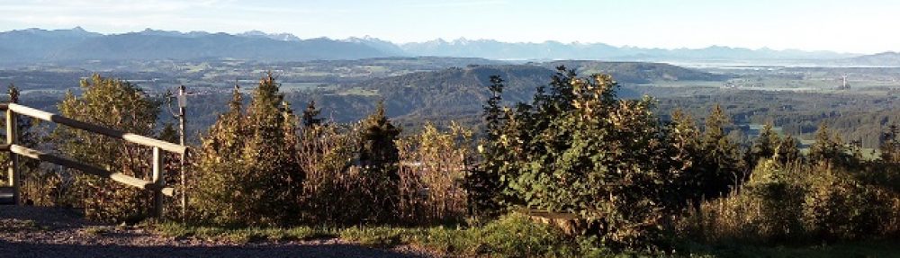
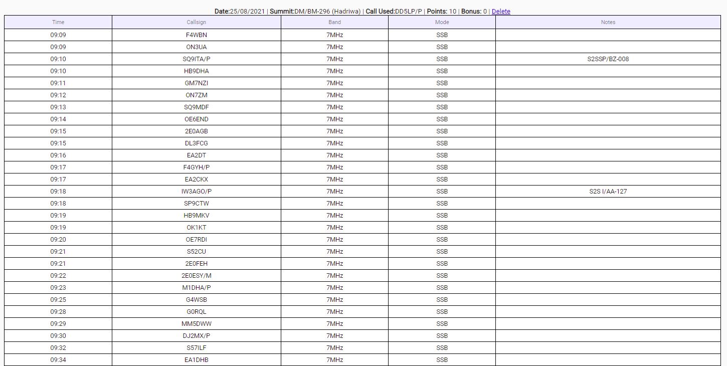
Activation – Hadriwa Wednesday 25/8/21
There are several points in the area marked as Hadriwa, so it’s important to go to the point given in the SOTA database and indicated on SOTAmaps. I had programmed the coordinates of the hiking car park between Maibrunn and Elisabethszell into my GPS and it took me there in about 10 minutes from HochPröller. On arriving, there were cars blocking each other in the car park as some wanted to leave and some new ones park so I drive further up the road but finding no alternative, drove back as I had seen a very small spot of concrete on the other side of the road and I thought, I might park there if I had to. As it happened when I got back, things were a little less chaotic and I was able to drive into the correct parking area and find a good spot.
This car park has some remembrance boards and a large map board with tracks marked on it. The reference number on the map however didn’t tally with the codes on the signposts, so I took a while to work out which tracks I would need to take from the map so that I would reach the Hadriwa high point as indicated in SOTA. The trick is to follow the “Hadriwa Höhenweg” signs which were also marked as “Nur für geübte” (only for experienced walkers). This warning was as much of the track was over rough rocky ground and slipping and twisting an ankle would be very easy to do. Upon reaching the high-point I asked another walker who was nearby having lunch with his son, whether this was the actual summit. He wasn’t sure but confirmed that the track goes down if I was to continue along the track – so it seems reasonable. After getting home I checked, I was in the right place and in any case that part of the track runs along a ridge and a long length of it is within the AZ (activation zone).
Perched on top of these rocks, the small antenna set-up definitely came into its own – I would not have been able to put up a dipole here in the space available!
This summit also got pülenty of calls from chasers including two S2S calls one from SQ9ITA Marcin and again from Heinrich IW3AGO. Space was limited but the weather was fine, indeed I actually put my cap on, on this summit. Mario DJ2MX from Munich was also staying in Bod Kotzting where our holiday apartment was and he had emailed me the previous day when he saw we were in the area and we had arranged to meet on Thursday (an action that unfortunately ended up getting cancelled due to the weather). Well, another contact from Hadriwa was indeed Mario who had set up his gear in the park and of course was a good signal. He suggested that as I was running ahead of schedule, and the weather is good, why not activate DM/BM-368 Schwarzriegel which I had cancelled the previous day. I told him I would consider this and by the time I had packed up and headed back to the car, that had become the plan. In hindsight, I’d have been better going to another summit local to where I was as Schwarzriegel was over 35 km away but I had a rough plan of how I would activate.
On setting off from Hadriwa the traffic had increased and as I approached one tourist park with lots of games for the children, the traffic stopped while more and more cars arrived and left the parking area. A little later up the road at another spot, it was the same. Everyone had come out with the children as it was, at last, a sunny day! The problem I now had to consider, along with a delayed drive, was that on arriving at Hohenbogen from where the chairlift goes up to the summit – is also a tourist area which would undoubtedly be overrun with people seeking a day out in the sunshine. So I reversed my decision and headed back to our holiday apartment planning to go perhaps to a closer summit on Thursday morning, before meeting Mario in the afternoon.
It was not to be. The heavy rain returned overnight and Thursday was such a wash-out and there was no likelihood of it improving so we decided to return home a day early.
Photos – Hadriwa:
Equipment used:
- Mountaintop travelling 40-litre rucksack.
- Xiegu G90 portable HF transceiver.
- Komunica HF-PRO2-Plus-T HF/VHF vertical and photo tripod with radials.
- Battery box (2 x 5000maH hard-case 4S LIPOs).
- Painters thick plastic sheet.
- Lightweight headphones.
- Also taken but not used on all summits – 6-metre Lambdahalbe mast and SOTABeams Linked dipole.
Log – Haidstein:

Log – Großer Arber:

Log – Pröller:

Log – Hadriwa:
Conclusions:
- With 944 activator points on my account after these activations, I still have a way to go to that magic 1000 – especially as closer to home, the summits that I can access are normally 1 or 2 pointers. OK at some point the winter bonus, 3-extra-points, will kick in on some summits but it’s still going to be a challenge to get to MG status by the end of the year.
- The radio gear worked without issue and really makes me wonder what advantage a mast and linked dipole is over the simple tripod and loaded vertical has? The simple vertical antenna teamed up with the photo tripod and the Xiegu G90 continues to amaze me how well it works! When the point is to bag a difficult summit, the extra work of installing the linked dipole or any other of my antennas is simply not worth it when I can work Europe from north to south and from west to east with this light and compact set-up. – I must do some antenna comparisons at some point.
- The new smartphone – an LG K42, was better in its “High-Contrast” mode (black backgrounds) but still was not easy to read as previous phones I have had. It connected to the 4G LTE network without any issues thankfully.
- This plan was DESTROYED by the constant rain and cold and this at the end of August when normally you could guarantee dry, warm weather. NEVER TRUST weather forecasts!
73 ’til the next summit(s).

You must be logged in to post a comment.