Preparation:
All equipment was prepared and loaded in the car the previous day even though I wasn’t planning a very early departure. These were not to be DX-seeking activations rather grabbing the last of the easy summits with winter bonus points before those stop at the end of the week.
The Activation (Blender):
Listening to the radio while having my breakfast with the snow falling outside, I head that the B12 (one of the roads I was intending to use), was totally blocked because of an accident. This meant a longer route via two Autobahns but not a lot of difference time wise. In any case I set off at 8:30 am instead of my planned 9am, – it’s always good to have some time in reserve.
I expected some delays around the Kempten ring road but the navi took me from the autobahn across country to avoid the town and its traffic. The downside of this is that I did not know the route and pulled up at a sign on the road which said access for those who live here only. But i could see the TV tower and before making a really long diversion, I decided to trust the Navi and drove down the road it suggested. part of the way down this road, the surface was gone and I was driving on a pot-holed mud track. Hoping not to get bogged I kept going and then as the tarmac returned, I realised where I was. The navi had brought me in from the other side to what I was used to. In any case I now headed to my usual parking spot, took out the gear I wanted to use, loaded myself up and started on the slog up the hill. I had decided to use the Vertically polarised two element (VP2E) 40/20m antenna on this summit as I knew it was fairly flat and I would be able to fit the antenna in. The temperatures were still cold and so I had my thick jacket on.
On arriving near the seat on the summit, I dropped everything down and proceeded to put the surveyors tripod up to support the 10 metre mast and the VP2E. All went well, but I was aware of some threatening cloud in the sky but luckily the rain held off.
I was not expecting any intercontinental DX as I was too late for long path and too early for short path. There was a time at the start when I wondered if I was getting out but after about 4 CQ calls the chasers appeared. Although I had checked and called to make sure the frequency wasn’t in use, as soon as I started to get calls, some station started up about 1 kHz away causing problems both for me and the chasers. This same problem actually occurred on all three summits!
Eleven contacts in 6 minutes and I was happy and packed up to head to the next summit, one that I have not activated for several years and it turns out that Urserberg isn’t that far from Blender especially if you take the narrow farm roads as directed by the navi!
The Activation (Urserberg):
On approaching Urserberg, I recognised where I was and drove straight into the car park, which is signposted as the car park for the Eschacher Weiher (pond) on the other side of the road. This is a good place to park as there is a track from here up the hill and the car is safely parked. The navi wanted to take me closer, around the other side of the hill, where I suspect the parking would not have been as good.
It is a fair walk up the track until you reach the summit (above the ski lifts), so I decided not to take the tripod this time chosing my screw-in sun umbrella base and 6 metre mast instead. To go with this I would use the Aerial-51 404-UL OCF dipole. I actually had all antennas in my rucksack, so I could choose a different one if I hit any problems. As had happened the previous week on Senkelekopf.
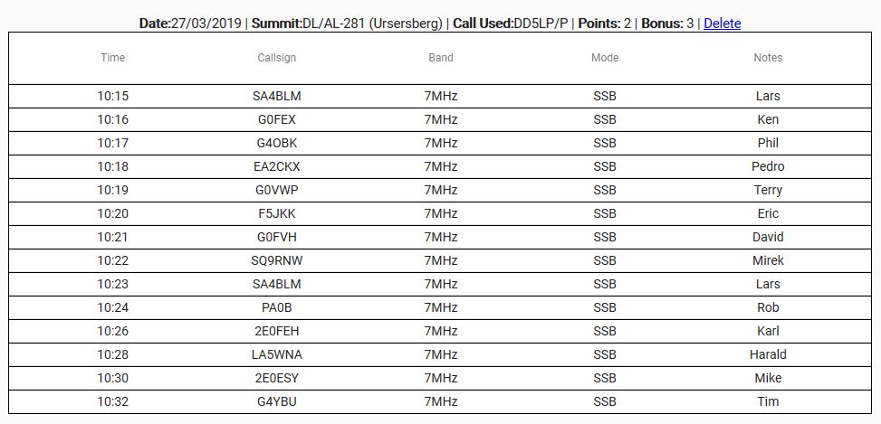
There’s no seat on this summit, so everything (including myself) was sat on my plastic painters sheet and after putting up the antenna and with some cold winds around, I managed 14 European contacts in 17 minutes, before packing up again to head off to the next summit. The walk up and down from this summit takes about 15 minutes and in my rush to get down I was not as careful as I should have been and slightly strained my ankle. Luckily this wasn’t as bad as it could have been but it underlines that rushing is not good in slippery conditions. I wasn’t going to let this stop me “bagging” summit number three of the day however, so once back at the car, it was time for a bit of lunch, reset the navi for the next summit and set off.
The Activation (Steig):
For some reason, this time the Navi decided to take me back via Kempten and there was some delay getting around the town but not as much as when I approached the summit. Previously I had used notes from Google maps to get to the car park and start of the walking trails in this forest-covered summit. This time I just gave in the summit reference and it directed me to the closed road to the summit – which just happened to end in a farm-yard at the other side of the summit where there are no official tracks to the summit from. To get me to this farm-yard, another length of mud track was included in the route so some interesting driving and some strange looks from the locals. Once I realised what had happened and having no way to tell the navi where the entrance to the forest was that I wanted, I reverted to Google Maps on my phone and was able to pick out two villages where I could tell the navi to bring me to and I knew the road between them and so found my parking spot for Steig with probably 40 minutes delay over a direct route.
This summit also entails a fairly long but not difficult walk, so again I opted for the lighter set-up and left the tripod and 10m mast in the car.
The forest looks a little different to what I remember as an awful lot of the trees have been cut down however the tracks are the same and I soon found my way up to the summit alongside the lookout platform.
Again the painters sheet became the base for operations and the SOTABeams linked dipole went up on the 6m mast and despite the QRM problem again on this summit, I bagged 12 contacts from around Europe in 10 minutes. At this summit the sun actually came out, so I felt like staying longer but as I had lost so much time through mis-navigation and the chance that the weather could change, I decided to pack up and head home, where I was by 15:30.
All in all good day out!
Photos (Blender):
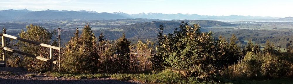
Photos (Urserberg):
Photos (Steig):
Equipment used:
Blender:
- Xiegu X108G plus battery box (2 x 5000maH hardcase LIPOs)
- Linked (40m/20m) VP2E antenna
- 10 metre DX-Wire fibreglass portable mast.
- Surveyors tripod.
- Smartphone PocketRxTx App and USB cable.
Urserberg:
- Xiegu X108G plus battery box (2 x 5000maH hardcase LIPOs).
- Aerial-51 OCF dipole antenna
- 10 metre DX-Wire fibreglass portable mast.
- Surveyors tripod.
- Thick plastic painters sheet.
- Smartphone PocketRxTx App and USB cable.
Steig:
- Xiegu X108G plus battery box (2 x 5000maH hardcase LIPOs)
- 6 metre lambdahalbe fibreglass portable mast.
- Thick plastic painters sheet
- SOTABeams Linked dipole
- Smartphone PocketRxTx App and USB cable
Log (Blender):
 Log (Urserberg):

 Log (Steig):
 Conclusions:

Don’t trust your Navi (GPS) to take you where you expect it to. I took the summit locations as a KML file from the SOTAMaps website. The Navi will try to get you as close as possible on a normal road but that isn’t always where the parking is or where the tracks go from.
I used different antennas on each of the three summits and all worked fine. I have the feeling that the VP2E was the best of the three and I will most likely use that one for the UK/EU – VK/JA/ZL S2S event on April 6th once I replace the centre mount which broke when I was taking it down at Blender.
73 ’til the next Summit!

You must be logged in to post a comment.