Preparation:
As I was in Lower Bavaria (Niederbayern) I decided to plan a visit to and activate what looked like a very straight forward summit in DM/BM-386 Enbersberg. At the same time I could test my wide-band vertical antenna with NVIS wire added at the same time. The mobile antenna – a Komunica Bazoka Pro from Spain has been used on previous activations with varying results. Mounted on a camera tripod, it has worked well on 40 metres but not so well on 20m. A discussion on the SOTA reflector alerted me to an antenna from the US that claimed to be wide-band AND good for both close in and DX contacts. The initial reaction was I can’t belive that, but looking at eHam reports the antenna from “Alpha Antennas” was getting some good reviews. Reading the online available, handbook for the antenna, it consists of a tripod with an earthing lead, an UNUN matching piece, a vertical whip and from the same connection above the UNUN, a 7.62m long wire, that should slope down to form half of an inverted-V configuration antenna for close in (up to 300 miles) communications. The vertical whip with its low angle of radiation adds the DX capabilities to the antenna. Looking at my Bazoka Pro configuration, I could easily emulate this antenna and indeed two tests, one in the garden at home and one at a portable location outside of the village, both showed that the antenna worked better with this extra wire connected to a conveniently already there hole at the top of the Bazoka’s UNUN, than without the wire. The Antenna analyser trace also showed a flatter SWR reading with the wire added than without.
I have all of the DM & DL summits programmed into my car GPS Navi but I also printed out a Google map and the instruction of how to get as close to the summit as possible. It looked like a short walk from a rough car park up to the look-out tower on the summit.
The Location:
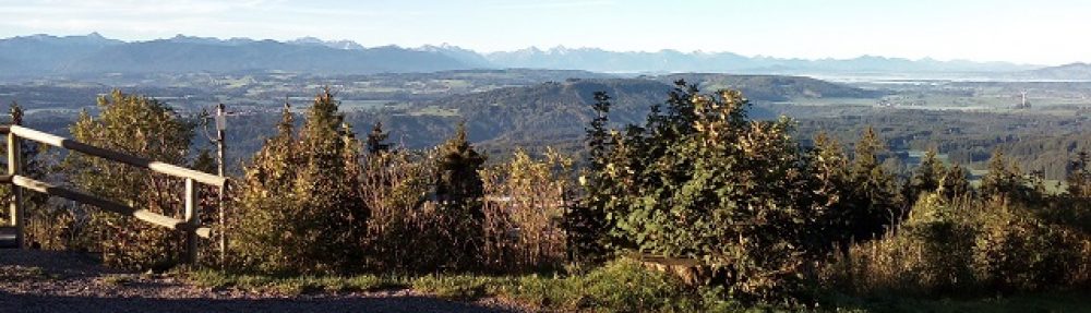
Ebersberg is near Kirchberg and following directions to Kirchberg will get you in the general area until you see road signs for Ebersberg. The summit is located on a range of hills that run along the northern banks of the Danube river, so views should be great on a clear day. There is in fact a Hamlet called Ebersberg that “should” be at the start of the track up to the summit (see report below, why I say “should”). The lookout tower should be a great location for a VHF activation with contacts likely possible into Austria and the Czech Republic as well as Germany if conditions are good. As I would have my dog Bonnie along, the tracks up to the summit through the forest should also be enjoyable for her as well. This is only the third time I have had Bonnie on an activation and the previous two times my wife was along and could take care of Bonnie if needed. This time it was just Bonnie and I.
The Activation:
The weather the two weeks prior to my planned visit was cold with snow and ice in Upper Bavaria (Oberbayern) where I live but there had been no snow, just a little drizzle and grey days in Lower Bavaria. That was until the day I travelled over when they had several centimeters of snow along with sleet and high winds. They were simply not ready for the weather, meaning when I set off from where I was staying about 40 minutes drive south of Ebersberg and the Danube valley, I was challenged with some “interesting” road conditions. Luckily as I got about 15 minutes north of my starting point the snow ploughs and gritting machines had been out and done a good job of clearing the roads. With temperatures around -1.5C and a lot of water on the road, along with one snow blizzard I still needed to take care and the 40 minute drive took just under an hour.
My Navi tried to take me via the autobahn but as I was hearing on the radio of many accidents causing blockages and delays on the Autobahns, I wanted to take the more direct, country roads route, which were actually quite good roads. After a while and a couple of “recalculating route” announcements, the Navi recognised the route I wanted to take and brought me nicely to the location. Well actually, that’s not 100% correct. At what I later realised was the very end of the journey, the Navi told me, “take a right turn in 100m”, “take the next right turn”. There was no right turn! I kept driving and got the “recalculating route” message again. The recalculated route, was to take me to the next village, turn me around and come back to the point where it had said make a right turn but this time it wanted me to take a left turn into this non-existent road. Then the penny dropped! The road was under 15cm of Snow drift and hadn’t been cleared. I could see a half-submerged information board at the end of what I guess was the rough car park, I had seen on Google Earth. So I parked the best I could half off the main (country) road, hoping that afterwards I would be able to get back onto the road! I picked up my bags, put a lead on the dog and we headed back up the road to where the turn-off should have been…
From that point I saw a metal archway, which appears to be over a track, as I could see some dog and owner tracks going up into the forest. Winter may stop the road clearers but when a dog needs to go out for its morning walk not even deep snow can stop it! Indeed this was the track and it isn’t very far at all up the track into the forest before one see’s the lookout tower and a flat round area in front of it. What I found interesting was, that there were a series of huts around the edge of this clearing. I wonder if these are still there from before Christmas and they were the sales huts for the Christmas market? Alternatively perhaps the locals hold events up here – the lookout tour was built by the local forestry club, so it could be that (when there’s not so much snow) they use the area for outside events. I had let Bonnie, my dog off the lead as we went under the archway and she seemed to be very obedient and that was one of the successes of this activation, that I could let the dog wander and investigate wherever she wanted but she came back every time I called her. This is a big thing as it means I can take her with me on future activations. She showed some interest while I was putting together the radio equipment and setting up the tripod mounted antenna but the woods and the huts around the area where far more interesting. I think we both enjoyed the morning out!
From a radio point of view, I was surprised to find a contest going on, on 40 metres. This was a Monday, contests are usually only on weekends. It seemed to be mostly Italian stations on the band, so perhaps an Italian national contest? The other thing I noticed after setting up, was, when tuned away from the loud contest stations, the atmospheric noise seemed very low. This was both on 40 metres and 20 metres. Later I checked and the K Index was only 1, which could be part of the reason but I suspect something else – perhaps the antenna, – perhaps the (IPO) pre-amp was turned off on these bands, perhaps I had turned the attenuator on by mistake? I checked at home and while I can’t be 100% sure, I think these settings were not wrong. In fact the problem may have been the multitude of strong stations, de-sensing the receiver and it would perhaps have been good to turn the IPO function off? From the reception reports that I got, I seemed to be getting out, despite the small antenna and the closeness of the trees. I’ll need to check this on the next activation.
My activation was a constant battle against the contest stations. as soon as I found a free frequency and started calling CQ, a station would start-up either on my frequency or so close to it that they splattered over it (again, had I thought of turning off IPO this may have helped). In any case it took some time to get the minimum 4 contacts required and I know there were others calling me but as soon as I heard part of a call sign, the QRM wiped out all but the very, very strong stations.
the temperature was “warm” for most of the time at around +2C but despite that after about an hour, my hands were starting to feel very cold and I was aware that at some point the dog would get bored or perhaps walk off and get lost. So after my 5th. contact I packed up and we left. All of the contacts were on 40 metres. I did try 20 metres for a short time but with no response to my spot and CQ call.
The drive back to where I was staying me the road clearers just starting to clear the roads around the village at about 12:30. All in all a nice outing and an area where I’d like to activate more summits but as the closest summit is at least 3 hours drive from my home QTH in good weather, I think any activations will have to wait until Summer.
Photos:
Equipment:
Yaesu FT817ND.
Komunica Bazoka Pro plus “NVIS wire”.
Photo tripod.
Modified Ramsey QAMP amplifier (30-35W on 40m).
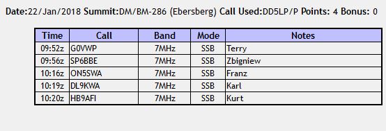
Log:
 Conclusions:

A great trip out, especially as regards how well the dog behaved but I am a little worried about the low noise level on the FT817 using the Bazoka antenna – more tests are needed.
73 ’til the next Summit!

You must be logged in to post a comment.