DD5LP – SOTA EUROPE – May 23rd. 2014 – DM/BM-226 Dürrenberg

Preparation:

As my wife had to attend a conference in Augsburg (about 1.5hrs away from here), I decided to take the opportunity to activate my first DM (German low mountains) summit (so far all had been DL (Alpine) ) and so “chalk up” another association. As the conference was to run for about 6 hours, I could pick a slightly higher scoring summit not close to Augsburg and I chose the 6 point Dürrenberg DM/BM-226 as it would be about another 1.5 Hrs drive north from Augsburg, giving me 1.5-2 hours on the summit before I had to return. Dürrenberg is also located within the Altmuhltal national park which for those interested in the WWFF award scheme has the DLFF code of DLFF-036.

I hoped that if conditions were any good I might get that elusive VK short path contact and failing that at around the same time I was planning to be active, some summits in the USA were also being activated so I might nab an S2S into the US..

The Location:

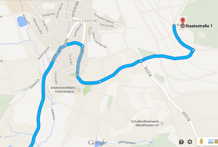
Dürrenberg is just outside of Heidenheim about 1.5 hours drive north of Augsburg. Max DK1MAX who was the last to activate this summit, kindly gave me some information about the final access. This is on an ex-military training area, so although public access is allowed, it’s on foot with a barrier blocking the access road. Fifteen minutes steady up hill walk from the public road is all that is required, so an “easy” summit to access.

. DM-BM-226 Dürrenberg map

The Activation:

Despite the weather forecast being for a nice sunny day with a possibility of a shower later, the day started off very grey and indeed on the way from Ammersee to Augsburg there were several rain showers. As I knew I would be traveling further north, I hoped the weather would clear up so that by about 14:30 (my planned time to arrive at site) the weather would be nice. Indeed the weather did clear up but this wasn’t to be my biggest problem …

This was probably my worst activation in Germany, perhaps overall !

Not because of equipment problems or band conditions (they weren’t great with weak signals and very, very deep QSB) but rather navigation to the site. I currently do not have a “navi”/GPS and so was relying upon a printout of the planned route from Google maps. Who would have thought there would be two IDENTICALLY NAMED towns both on the same main road – the 466! Add to this the point where I had to turn onto this road was a town called Nordlingen where Haidenheim was already signposted. Great I thought, I’ll simply follow the road signs now rather than trying to read the notes while driving. Of course, as luck would have it, the Haidenheim that was signposted was the WRONG ONE. I should have realised that so far away from the small Heidenheim village, it would not be already signposted. I diligently followed the signs and only when I got to the signposted Heidenheim did I smell a rat as I could not find the roads that I expected to have to follow and this was a TOWN not a VILLAGE. Once I checked my location using the maps program on my smart phone, I saw it saying I was probably nearly 100km away from the location I wanted to be at and this was quickly approaching my alerted start time. I had two choices, to try to get to the correct Heidenheim and then up to Dürrenberg and have a very short activation before hi-tailing it back to Augsburg or cancel the activation. I decided on the former and after getting lost in Nordlingen because of incorrect signage in the town twice, I eventually found the 466 road in the correct direction out of town.

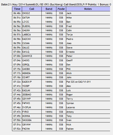
So after about four hours driving for what should have been 1.5 hours I arrived at Dürrenberg at about 15:50 local time. After setting up, spotting and calling for what seemed like an age, I got a call from Mike, G6TUH in England followed by Jorge EA2LU and Manual EA2DT from Spain and then nothing!  I tried 2m FM – no response (not surprising as I only had the HT and it’s rubber-duck style antenna)..

I still needed one more contact to be able to claim the activation and it was already time that I should be packing up to head back to Augsburg. I switched to 40m and luckily picked up two stations from the Slovak Republic Martin OM5DP and Vlado OM1AX, which made 5 contacts from the summit. One last call – no takers, so I packed up and headed back down the hill to the car and back to Augsburg to pick up my wife about 15 minutes later than originally planned.

By the time we arrived home, I have been traveling for over 6 hours and as the Ozzies say “I was bushed”.

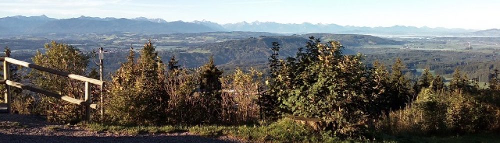
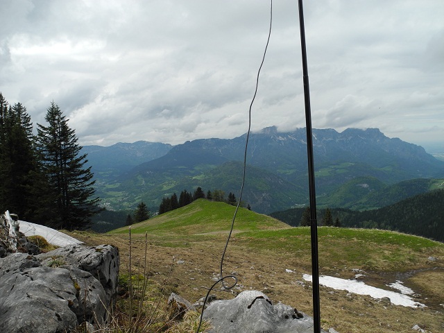
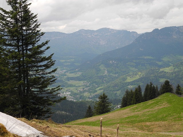
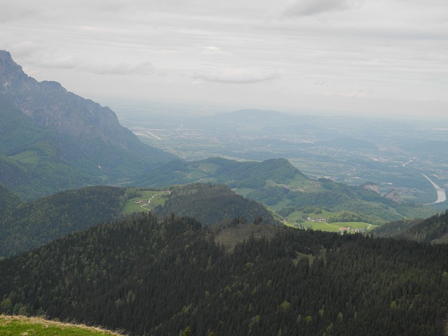
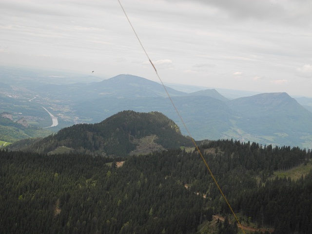
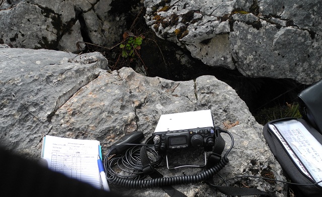
To prove I was there, I also took some photos. The support for the squid pole that you can see is an air vent, possibly from some underground bunker on the site:.

This slideshow requires JavaScript.

Equipment:

FT817ND (running barefoot this time)..

SOTABeams Linked dipole

Conclusions:

Always double check a route. Do not rely on roadsigns. Ideally have a navigator – either a person or a machine to double check the route you are driving.

Late afternoon is currently not a good time for HF QRP QSOs from summits in Europe.

73 ’til the next Summit!

DD5LP – SOTA EUROPE – May 21st. 2014 – DL/BE-093 Buchberg

Preparation:

Having some time available and a good weather forecast, i wanted to get out and activate a summit again. If it could be close enough to where I live, I might even get some long path contacts back into Australia again..

I decided to take the standard equipment and stick to 20m SSB. So the FT817 (LIPO) battery was charged up, as was the 5Ah 3S LIPO that I use to run my small Ramsey amplifier, which I haven’t started my planned mods to, even though the parts arrived a couple of days before. Better to leave things working as they have been rather than change things with no fall back option!

The hill chosen is about an hours drive away and I had intended doing a “reccie” on the previous Sunday however I was quite ill that day and so I decided I would have to simply go by what I could see from Google maps and its satellite pictures.

The Location:

Buchberg is located not far away from Bad Tölz and across the road almost from the skilift up to the base of Zweisselberg, another SOTA summit that I would like to activate at some point.

The plotted route had me turning off the main B472 road on an unsignposted road and then running along the edge of a forest to the village of Buchberg and then taking one of several walking tracks to the summit. On looking at the layout, my fallback position would be to operate from within a forest just down from the summit as it is still within the AZ. DL-BE-093_Buchberg-map

The Activation:

 The morning started well with sunny weather and not too much traffic. Of course I drove past the un-signposted road off the B472. For others intending to activate this summit, the road is about 200m before the Gastehaus Wiessweber, which is just before the big lake (called Hinterstauau).

The road off the B472 is a single track road but with a proper surface. On getting to the point where I should turn off on the track along the edge of the forest, I was faced with a sign that said access is restricted to farm and forestry vehicles only.. Not wanting to get locked up for trespass, I started to look for an alternative route.

At this point the farmer from the farm across the road came along with his dogs and I decided to ask him if there was another route to Buchberg. He immediately said ignore the sign, everyone uses that road and it’s not private. On that basis I decided that rather than calling off the activation I’d risk it. The track was a little rough however no where near as bad as several tracks I have driven along with my low clearance Peugeot 308 in Australia and now I have a Ford Galaxy family van which has at least twice the road clearance that the Peugeot had.

At the end of the track I came into the village of Buchberg which is actually just a farm. On the other side was the track that runs half way up to the summit but it was clearly marked as no through road and it looked as if I would not be able to turn around when I got to the end of it.

I decided therefore to go to my backup position near the forest which was on the road going out of the other side of Buchberg. This turned out to be a narrow however properly surfaced road that I used when I completed the activation. It ran down the hill into Bad Tölz passing the Golf Course and Buchberg Clinic and the on the way. For future activators this would be the way to get to Buchberg if you don’t want to risk the forestry track. Take directions in Bad Tölz to the Buchberg Clinic and then after the clinic turn left (there is a sign to Buchberg on this junction) go past the golf club and keep on winding up the road for probably about 5 kilometers and you will arrive at Buchberg..

Back to the activation site. I parked up off the road near the forest and looked around for somewhere to set-up. I could not find anywhere that looked like I could fasten the squiddy to and have the antenna clear of the trees without being definitely on a farmers land or right next to the (narrow) road. I then looked up to the summit itself to see a large wooden cross that the squiddy should be able to be strapped to without any great effort. So that was the choice, no secondary option, i would activate from the very summit. Given the cross being there and the footpaths listed to it on  the maps, this “should” be public access. I walked up the side of the field and across the top to the summit (you should never walk directly across a farmers field as you can damage the crop, whereas the edge of a field is often considered waste land). On arriving at the summit I found there was even a bench to sit on – LUXURY!

So I started to set up all the equipment as usual, trying to angle the antenna to allows a NW/SE radiation towards VK long path. Just down from the summit and not visible until you get to the summit is another farm / residence and after a while I got a visit asking what I was doing by a gentleman from this farm. After a few minutes discussion he was happy I wasn’t going to damage or steal the cross and so all was OK.

Now at last, time to start the activation….

I started on 20m trying to call some OE activators who were already on the air but I simply could not get through the pile ups. Even after one chaser kindly told one of the stations that they had a summit-to-summit call, they still could not hear me. With the mixture or QRM and deep QSB that was the story of this activation. I did manage one S2S contact into Spain but most other activators simply could not hear me. Later I found out that they were all running 100W RF while I was down in the noise with my 5-8W.

I called a couple of times specifically for VK chasers with no success however looking at all of the chasers I did work around Europe, I shouldn’t complain. Apart from the S2S into Spain, the other highlights were contacts with The Azores and Denmark, Norway & Sweden. The full log is shown below.

The real success of this activation was getting out in the fresh air and again enjoying some unbelievable  views. I have put together a gallery of some of the best views below.

This slideshow requires JavaScript.

Equipment:

FT817ND

Ramsey QAMP amplifier

SOTABeams Linked dipole

Log:

DL-BE-093_Buchberg-log

Conclusions:

A good activation. it would have been better if I had managed a long path conrtact back into VK but with the band conditions, that just wasn’t going to happen. I think the next time I try this however I will start earlier which would at least avoid some of the heavy QRM from such a busy band. Perhaps next time I will have a 17m antenna made up so that I can switch to that (quieter) band.Unfortunately many of the VK chasers can’t operate on the WARC bands, so maybe 15m as well would be a good idea.

73 ’til the next Summit!

DD5LP – SOTA EUROPE – May 10th. 2014 – DL/BG-023 Ahornbüchsenkopf

Preparation:

Saturday the 10th. of May was the first (forecast) dry day for over a week at the Ahornbüchsenkopf summit so I deceided to go ahead with this activation that had been canceled the previous weekend due to an extreme weather warning.

The activation was combined with a visit to a friend who then accompanied my wife and I to the Ahornkaser restaurant, which lies about 60 meters below the SOTA summit.

The fact that a visit to a friend and the 2.5 hour drive to get to the area from where I am living meant the start time of the activation was set at 2:30pm local, we were also limited in how long I could stay on the summit by the expected autobahn traffic levels on the return home. I had hoped for 90 minutes on the summit but this turned out not to be possible.

The Location:

The Ahornkaser restaurant that would form my “base camp” lies about 60 meters below the Ahornbüchsenkopf summit and is the highest road-accessible restaurant in Bavaria.

The Ahornkaser lies just off the “Rossfeld Panorama Strasse” not far from Berchtesgaden in SW Baravia.The road, which runs along the German / Austrian border, rises to 1570m at its highest point, just past the turn off for the Ahornkaser restaurant.

Tourist-map

The Activation:

 The morning did not start well with overcast weather on the way down but by 11am the sun had broken through and the temperature risen somewhat.

 On getting to the bottom of the ~ 60m summit climb at just before 2pm, I found the ground to be waterlogged. Parts could only be described as a bog. The week of heavy rain that the region received over the preceding week had obviously taken its toll. This made the climb / walk more time consuming as I had to work my way around the worst spots. The track to the top was not visible at this stage however as I got higher, at about 15-20 vertical metres from the top, the track was there but like the ground around it, it was under half a metre of melting snow. The snow would not support my weight so I found some rocks at the snow line and used that as my base, setting up antenna and rig as best I could. I would have like to have got to the summit and use the convenient table and seating bank however it was not safe to proceed any further.

As I sat, perched on my rock on the side of this mountain and looked out I realised how high up I was and how far I could see into Austria and back into Germany. I hoped that the fact that I could only manage to get the centre of the inverted-V dipole up to about 3.5m above ground instead of the usual 5m would not be such a problem given the location. What I could also see were some storms forming on neighbouring mountains, so no time to lose and it was nearly my advertised time to be on-air in any case.

I started on 20m and while there were the usual strong European stations, I could not hear any DX. I was hoping to make some short path contacts back into Australia as I had managed long path contacts on previous activations from lower summits. I found a free frequency and started calling CQ-SOTA and spotted myself on SOTAWatch using RRT at the same time. Cell phone coverage should be good in the area however my phone had the problem that it kept switching between the German & Austrian mobile phone cells and kept sending me SMS warnings about roaming charges. In any case when I stopped calling, there was Don G0RQL from Devon in England booming in as usual. Contacts with a few other European stations followed (see log below) but when I saw a Norwegian activator spotted on SOTAWatch I went after him and succeeded in making an S2S contact. Apparently there were several European SOTA activators out but they were on either different bands and mode than I could run or they were simply not active when I was.

 After the S-2-S contact I worked a couple more stations on 20m before trying 40m. At this point the mobile phone cells were even more difficult to access than before, making it very difficult for me to self-spot. I put out CQs for about 15 minutes with no responses, before light rain started at about 3pm local time. As I could see the storm coming towards me this was not a shower that would pass and indeed after I had packed up and carefully picked my way back down the mountain slope to the restaurant, a heavy storm came through.

DSCN1799-640 DSCN1800-640 DSCN1801-640 DSCN1802-640 DSCN1803-640 DSCN1805-640

Equipment:

FT817ND

SOTABeams Linked dipole

Log:

SOTA-Activators-logConclusions:

Not the best activation. A lot of work for being operational only half an hour. Activating later in the year when the snow had gone and later in the afternoon would have probably been better for propagation. But those views! even with the clouds, the views were fantastic, definitely more than the photos can show. Perhaps I’ll activate this summit again in 2015?

73 ’til the next Summit!